Busby geodata
Busby (New South Wales) is a section of populated place; located in Australia in Australia/Sydney (GMT+10) time zone. With population of 4,280 people, there are 1690 cities with bigger population in this country. Compared to other cities in Australia, 56.4% of cities are located further ↑North; 64.9% of cities are located further ←West and 60.7% of cities have lower elevation than Busby. Note1


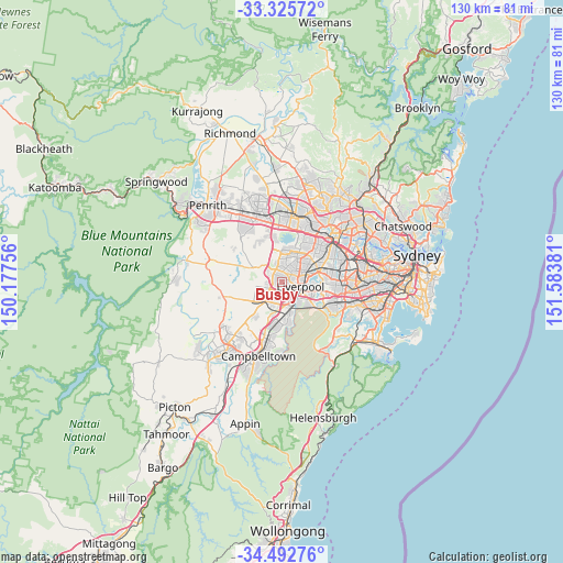
Busby GPS coordinates[2]
33° 54' 40.464" South, 150° 52' 50.448" East
| Map corner | latitude | longitude |
|---|---|---|
| Upper-left | -33.32572°, | 150.17756° |
| Center: | -33.91124°, | 150.88068° |
| Lower-right: | -34.49276°, | 151.58381° |
| Map W x H: | 129.8×129.8 km | = 80.7×80.7mi |
| max Lat: | -10.58257° ⇑56.4% North |
| Busby: | -33.91124° |
| min Lat: | ⇓43.6% South -43.31423° |
| min Long | Busby | max Long |
| 113.53327° | 150.88068° | 153.61246° |
| W 64.9%⇐ | ⇒35.1% E |
Elevation
Elevation of Busby is 66 m = 217 ft, and this is 56 m = 184 ft below average elevation for this country.
| Max E: |
1715 m = 5627 ft | 39.3% |
| Avg. | 122 m = 400 ft | |
| Busby | 66 m = 217 ft | |
Min E: |
-2 m = -7 ft | 60.7% |
See also: Australia elevation on elevation.city.
Geographical zone
Busby is located in South temperate zone (between Tropic of Capricorn and the Antarctic Circle). Distance of this Southern Tropic circle is 1164.7 km =723.7 mi to North.| Distance of | km | miles | from Busby |
|---|---|---|---|
| Equator | 3770.6 | 2342.9 | to North |
| Tropic Capricorn | 1164.7 | 723.7 | to North |
| Antarctic Circle | 3630.6 | 2255.9 | to South |
| South Pole | 6236.5 | 3875.2 | to South |


Nearby cities:
15 places around Busby: (largest is in red/bold)
• Ashcroft
1.8 km =1.1 mi,  106°
106°
• Bonnyrigg
2.1 km =1.3 mi,  21°
21°
• Bonnyrigg Heights
2.4 km =1.5 mi,  336°
336°
• Cabramatta West
3.5 km =2.2 mi,  54°
54°
• Cartwright
1.7 km =1.1 mi,  151°
151°
• Elizabeth Hills
3.4 km =2.1 mi,  294°
294°
• Green Valley
1.6 km =1 mi,  306°
306°
• Heckenberg
0.9 km =0.6 mi,  68°
68°
• Hinchinbrook
1.8 km =1.1 mi,  242°
242°
• Hoxton Park
3.3 km =2.1 mi,  227°
227°
• Lurnea
3.1 km =1.9 mi, 151°
• Miller
1.1 km =0.7 mi,  160°
160°
• Mount Pritchard
2.4 km =1.5 mi, 67°
• Prestons
3.5 km =2.2 mi,  193°
193°
• Sadleir
1.2 km =0.7 mi,  124°
124°
Sources, notices
• [Note1] Compared only with cities in Australia existing in our database
• [Src1] Map data: © OpenStreetMap contributors (CC-BY-SA)
• [Src2] Other city data from geonames.org with taken over terms of usage.
• [Src3] Geographical zone / Annual Mean Temperature by Robert A. Rohde @ Wikipedia
