Daglish geodata
Daglish (Western Australia) is a section of populated place; located in Australia in Australia/Perth (GMT+8) time zone. With population of 1,399 people, there are 3369 cities with bigger population in this country. Compared to other cities in Australia, 65.8% of cities are located further ↓South; 95.8% of cities are located further →East and 64.8% of cities have higher elevation than Daglish. Note1


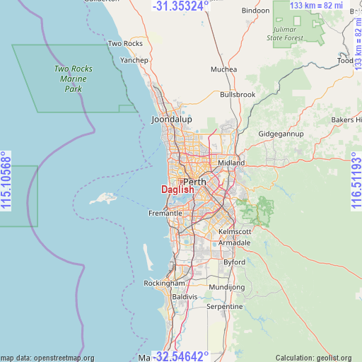
Daglish GPS coordinates[2]
31° 57' 6.372" South, 115° 48' 31.68" East
| Map corner | latitude | longitude |
|---|---|---|
| Upper-left | -31.35324°, | 115.10568° |
| Center: | -31.95177°, | 115.8088° |
| Lower-right: | -32.54642°, | 116.51193° |
| Map W x H: | 132.7×132.7 km | = 82.5×82.5mi |
| max Lat: | -10.58257° ⇑34.2% North |
| Daglish: | -31.95177° |
| min Lat: | ⇓65.8% South -43.31423° |
| min Long | Daglish | max Long |
| 113.53327° | 115.8088° | 153.61246° |
| W 4.2%⇐ | ⇒95.8% E |
Elevation
Elevation of Daglish is 27 m = 89 ft, and this is 95 m = 312 ft below average elevation for this country.
| Max E: |
1715 m = 5627 ft | 64.8% |
| Avg. | 122 m = 400 ft | |
| Daglish | 27 m = 89 ft | |
Min E: |
-2 m = -7 ft | 35.2% |
See also: Australia elevation on elevation.city.
Geographical zone
Daglish is located in South temperate zone (between Tropic of Capricorn and the Antarctic Circle). Distance of this Southern Tropic circle is 946.8 km =588.3 mi to North.| Distance of | km | miles | from Daglish |
|---|---|---|---|
| Equator | 3552.7 | 2207.5 | to North |
| Tropic Capricorn | 946.8 | 588.3 | to North |
| Antarctic Circle | 3848.5 | 2391.3 | to South |
| South Pole | 6454.4 | 4010.6 | to South |


Nearby cities:
15 places around Daglish: (largest is in red/bold)
• Churchlands
3.7 km =2.3 mi,  336°
336°
• Claremont
4 km =2.5 mi,  218°
218°
• Crawley
3.7 km =2.3 mi,  169°
169°
• Floreat
2.1 km =1.3 mi,  312°
312°
• Glendalough
3.7 km =2.3 mi,  15°
15°
• Jolimont
0.7 km =0.4 mi,  5°
5°
• Leederville
3.6 km =2.2 mi,  61°
61°
• Mount Claremont
2.6 km =1.6 mi,  245°
245°
• Nedlands
3.3 km =2.1 mi,  182°
182°
• Perth city centre
4 km =2.5 mi,  91°
91°
• Shenton Park
1.1 km =0.7 mi, 246°
• Subiaco
1.7 km =1.1 mi,  77°
77°
• Wembley
2.2 km =1.4 mi, 22°
• West Leederville
2.4 km =1.5 mi, 61°
• West Perth
3.1 km =1.9 mi, 84°
Sources, notices
• [Note1] Compared only with cities in Australia existing in our database
• [Src1] Map data: © OpenStreetMap contributors (CC-BY-SA)
• [Src2] Other city data from geonames.org with taken over terms of usage.
• [Src3] Geographical zone / Annual Mean Temperature by Robert A. Rohde @ Wikipedia
