Underdale geodata
Underdale (South Australia) is a section of populated place; located in Australia in Australia/Adelaide (GMT+10.5) time zone. With population of 2,282 people, there are 2702 cities with bigger population in this country. Compared to other cities in Australia, 68.9% of cities are located further ↑North; 83.1% of cities are located further →East and 85% of cities have higher elevation than Underdale. Note1


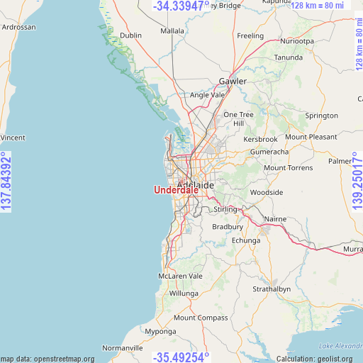
Underdale GPS coordinates[2]
34° 55' 4.908" South, 138° 32' 49.344" East
| Map corner | latitude | longitude |
|---|---|---|
| Upper-left | -34.33947°, | 137.84392° |
| Center: | -34.91803°, | 138.54704° |
| Lower-right: | -35.49254°, | 139.25017° |
| Map W x H: | 128.2×128.2 km | = 79.7×79.7mi |
| max Lat: | -10.58257° ⇑68.9% North |
| Underdale: | -34.91803° |
| min Lat: | ⇓31.1% South -43.31423° |
| min Long | Underdale | max Long |
| 113.53327° | 138.54704° | 153.61246° |
| W 16.9%⇐ | ⇒83.1% E |
Elevation
Elevation of Underdale is 12 m = 39 ft, and this is 110 m = 361 ft below average elevation for this country.
| Max E: |
1715 m = 5627 ft | 85% |
| Avg. | 122 m = 400 ft | |
| Underdale | 12 m = 39 ft | |
Min E: |
-2 m = -7 ft | 15% |
See also: Australia elevation on elevation.city.
Geographical zone
Underdale is located in South temperate zone (between Tropic of Capricorn and the Antarctic Circle). Distance of this Southern Tropic circle is 1276.6 km =793.2 mi to North.| Distance of | km | miles | from Underdale |
|---|---|---|---|
| Equator | 3882.5 | 2412.5 | to North |
| Tropic Capricorn | 1276.6 | 793.2 | to North |
| Antarctic Circle | 3518.7 | 2186.4 | to South |
| South Pole | 6124.5 | 3805.6 | to South |


Nearby cities:
15 places around Underdale: (largest is in red/bold)
• Allenby Gardens
2.4 km =1.5 mi,  16°
16°
• Beverley
2.5 km =1.6 mi,  358°
358°
• Brooklyn Park
1.5 km =0.9 mi,  220°
220°
• Cowandilla
1.9 km =1.2 mi,  144°
144°
• Findon
2.4 km =1.5 mi,  328°
328°
• Flinders Park
0.9 km =0.6 mi,  338°
338°
• Hilton
2.2 km =1.4 mi,  134°
134°
• Kidman Park
1.9 km =1.2 mi,  289°
289°
• Lockleys
1.9 km =1.2 mi,  243°
243°
• Mile End
2.3 km =1.4 mi,  114°
114°
• Thebarton
1.8 km =1.1 mi,  85°
85°
• Torrensville
1.3 km =0.8 mi,  101°
101°
• Welland
1.9 km =1.2 mi,  32°
32°
• West Hindmarsh
1.9 km =1.2 mi,  54°
54°
• Westrichmond
2.3 km =1.4 mi,  168°
168°
Sources, notices
• [Note1] Compared only with cities in Australia existing in our database
• [Src1] Map data: © OpenStreetMap contributors (CC-BY-SA)
• [Src2] Other city data from geonames.org with taken over terms of usage.
• [Src3] Geographical zone / Annual Mean Temperature by Robert A. Rohde @ Wikipedia
