Findon geodata
Findon (South Australia) is a section of populated place; located in Australia in Australia/Adelaide (GMT+10.5) time zone. With population of 6,178 people, there are 1160 cities with bigger population in this country. Compared to other cities in Australia, 68.2% of cities are located further ↑North; 83.6% of cities are located further →East and 85% of cities have higher elevation than Findon. Note1


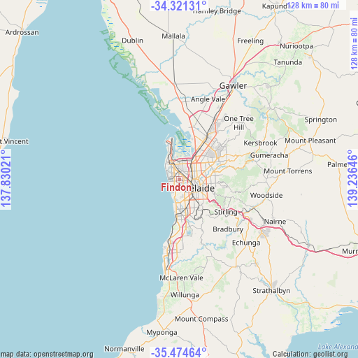
Findon GPS coordinates[2]
34° 54' 0" South, 138° 31' 59.988" East
| Map corner | latitude | longitude |
|---|---|---|
| Upper-left | -34.32131°, | 137.83021° |
| Center: | -34.9°, | 138.53333° |
| Lower-right: | -35.47464°, | 139.23646° |
| Map W x H: | 128.2×128.2 km | = 79.7×79.7mi |
| max Lat: | -10.58257° ⇑68.2% North |
| Findon: | -34.9° |
| min Lat: | ⇓31.8% South -43.31423° |
| min Long | Findon | max Long |
| 113.53327° | 138.53333° | 153.61246° |
| W 16.4%⇐ | ⇒83.6% E |
Elevation
Elevation of Findon is 12 m = 39 ft, and this is 110 m = 361 ft below average elevation for this country.
| Max E: |
1715 m = 5627 ft | 85% |
| Avg. | 122 m = 400 ft | |
| Findon | 12 m = 39 ft | |
Min E: |
-2 m = -7 ft | 15% |
See also: Australia elevation on elevation.city.
Geographical zone
Findon is located in South temperate zone (between Tropic of Capricorn and the Antarctic Circle). Distance of this Southern Tropic circle is 1274.6 km =792 mi to North.| Distance of | km | miles | from Findon |
|---|---|---|---|
| Equator | 3880.5 | 2411.2 | to North |
| Tropic Capricorn | 1274.6 | 792 | to North |
| Antarctic Circle | 3520.7 | 2187.7 | to South |
| South Pole | 6126.5 | 3806.8 | to South |


Nearby cities:
15 places around Findon: (largest is in red/bold)
• Allenby Gardens
1.9 km =1.2 mi,  82°
82°
• Beverley
1.3 km =0.8 mi,  65°
65°
• Flinders Park
1.5 km =0.9 mi,  141°
141°
• Fulham Gardens
2.5 km =1.6 mi,  228°
228°
• Kidman Park
1.5 km =0.9 mi,  203°
203°
• Kilkenny
2.9 km =1.8 mi,  37°
37°
• Seaton
1.5 km =0.9 mi,  270°
270°
• Underdale
2.4 km =1.5 mi,  148°
148°
• Welland
2.3 km =1.4 mi,  100°
100°
• West Croydon
2.4 km =1.5 mi, 75°
• West Hindmarsh
2.9 km =1.8 mi,  107°
107°
• Woodville
2.7 km =1.7 mi,  18°
18°
• Woodville Park
1.9 km =1.2 mi, 39°
• Woodville South
2 km =1.2 mi,  3°
3°
• Woodville West
1.5 km =0.9 mi,  351°
351°
Sources, notices
• [Note1] Compared only with cities in Australia existing in our database
• [Src1] Map data: © OpenStreetMap contributors (CC-BY-SA)
• [Src2] Other city data from geonames.org with taken over terms of usage.
• [Src3] Geographical zone / Annual Mean Temperature by Robert A. Rohde @ Wikipedia
