Beverley geodata
Beverley (South Australia) is a section of populated place; located in Australia in Australia/Adelaide (GMT+10.5) time zone. With population of 1,476 people, there are 3298 cities with bigger population in this country. Compared to other cities in Australia, 68% of cities are located further ↑North; 83.1% of cities are located further →East and 79% of cities have higher elevation than Beverley. Note1


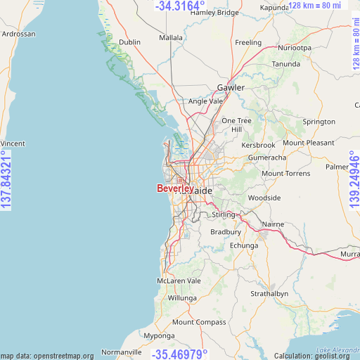
Beverley GPS coordinates[2]
34° 53' 42.432" South, 138° 32' 46.788" East
| Map corner | latitude | longitude |
|---|---|---|
| Upper-left | -34.3164°, | 137.84321° |
| Center: | -34.89512°, | 138.54633° |
| Lower-right: | -35.46979°, | 139.24946° |
| Map W x H: | 128.2×128.2 km | = 79.7×79.7mi |
| max Lat: | -10.58257° ⇑68% North |
| Beverley: | -34.89512° |
| min Lat: | ⇓32% South -43.31423° |
| min Long | Beverley | max Long |
| 113.53327° | 138.54633° | 153.61246° |
| W 16.9%⇐ | ⇒83.1% E |
Elevation
Elevation of Beverley is 16 m = 52 ft, and this is 106 m = 348 ft below average elevation for this country.
| Max E: |
1715 m = 5627 ft | 79% |
| Avg. | 122 m = 400 ft | |
| Beverley | 16 m = 52 ft | |
Min E: |
-2 m = -7 ft | 21% |
See also: Australia elevation on elevation.city.
Geographical zone
Beverley is located in South temperate zone (between Tropic of Capricorn and the Antarctic Circle). Distance of this Southern Tropic circle is 1274.1 km =791.7 mi to North.| Distance of | km | miles | from Beverley |
|---|---|---|---|
| Equator | 3880 | 2410.9 | to North |
| Tropic Capricorn | 1274.1 | 791.7 | to North |
| Antarctic Circle | 3521.2 | 2188 | to South |
| South Pole | 6127.1 | 3807.2 | to South |


Nearby cities:
15 places around Beverley: (largest is in red/bold)
• Allenby Gardens
0.8 km =0.5 mi,  111°
111°
• Croydon Park
2.6 km =1.6 mi,  49°
49°
• Findon
1.3 km =0.8 mi,  245°
245°
• Flinders Park
1.7 km =1.1 mi,  189°
189°
• Kidman Park
2.6 km =1.6 mi,  222°
222°
• Kilkenny
1.9 km =1.2 mi,  18°
18°
• Ridleyton
2.3 km =1.4 mi,  83°
83°
• Underdale
2.5 km =1.6 mi,  178°
178°
• Welland
1.5 km =0.9 mi,  130°
130°
• West Croydon
1.2 km =0.7 mi,  86°
86°
• West Hindmarsh
2.2 km =1.4 mi, 131°
• Woodville
2 km =1.2 mi,  351°
351°
• Woodville Park
0.9 km =0.6 mi,  0°
0°
• Woodville South
1.8 km =1.1 mi,  324°
324°
• Woodville West
1.7 km =1.1 mi,  304°
304°
Sources, notices
• [Note1] Compared only with cities in Australia existing in our database
• [Src1] Map data: © OpenStreetMap contributors (CC-BY-SA)
• [Src2] Other city data from geonames.org with taken over terms of usage.
• [Src3] Geographical zone / Annual Mean Temperature by Robert A. Rohde @ Wikipedia
