Campsie geodata
Campsie (New South Wales) is a section of populated place; located in Australia in Australia/Sydney (GMT+11) time zone. With population of 24,487 people, there are 107 cities with bigger population in this country. Compared to other cities in Australia, 56.5% of cities are located further ↑North; 70% of cities are located further ←West and 58.4% of cities have higher elevation than Campsie. Note1


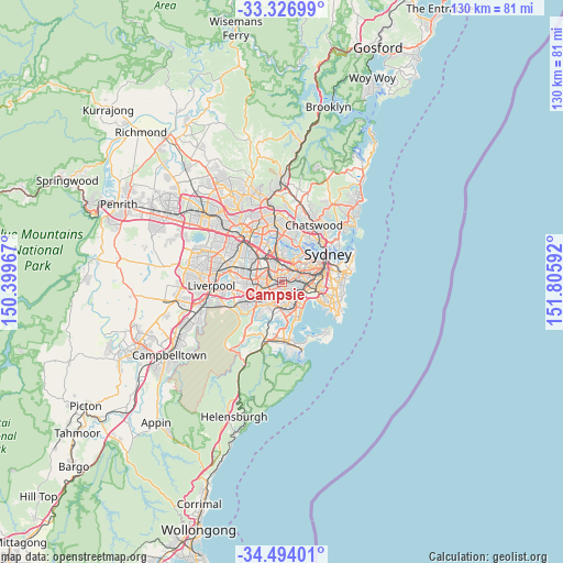
Campsie GPS coordinates[2]
33° 54' 45" South, 151° 6' 10.044" East
| Map corner | latitude | longitude |
|---|---|---|
| Upper-left | -33.32699°, | 150.39967° |
| Center: | -33.9125°, | 151.10279° |
| Lower-right: | -34.49401°, | 151.80592° |
| Map W x H: | 129.8×129.8 km | = 80.7×80.7mi |
| max Lat: | -10.58257° ⇑56.5% North |
| Campsie: | -33.9125° |
| min Lat: | ⇓43.5% South -43.31423° |
| min Long | Campsie | max Long |
| 113.53327° | 151.10279° | 153.61246° |
| W 70%⇐ | ⇒30% E |
Elevation
Elevation of Campsie is 34 m = 112 ft, and this is 88 m = 289 ft below average elevation for this country.
| Max E: |
1715 m = 5627 ft | 58.4% |
| Avg. | 122 m = 400 ft | |
| Campsie | 34 m = 112 ft | |
Min E: |
-2 m = -7 ft | 41.6% |
See also: Australia elevation on elevation.city.
Geographical zone
Campsie is located in South temperate zone (between Tropic of Capricorn and the Antarctic Circle). Distance of this Southern Tropic circle is 1164.8 km =723.8 mi to North.| Distance of | km | miles | from Campsie |
|---|---|---|---|
| Equator | 3770.7 | 2343 | to North |
| Tropic Capricorn | 1164.8 | 723.8 | to North |
| Antarctic Circle | 3630.5 | 2255.9 | to South |
| South Pole | 6236.3 | 3875.1 | to South |


Nearby cities:
15 places around Campsie: (largest is in red/bold)
• Ashbury
2.2 km =1.4 mi,  43°
43°
• Ashfield
3.3 km =2.1 mi,  34°
34°
• Bardwell Park
3.3 km =2.1 mi,  140°
140°
• Belfield
1.9 km =1.2 mi,  300°
300°
• Belmore
1.4 km =0.9 mi,  239°
239°
• Bexley North
3.1 km =1.9 mi,  160°
160°
• Burwood
3.3 km =2.1 mi,  355°
355°
• Burwood Heights
2.6 km =1.6 mi,  2°
2°
• Canterbury
1.5 km =0.9 mi,  87°
87°
• Clemton Park
1.5 km =0.9 mi,  175°
175°
• Earlwood
2.3 km =1.4 mi,  114°
114°
• Hurlstone Park
2.4 km =1.5 mi,  83°
83°
• Kingsgrove
3 km =1.9 mi,  186°
186°
• Lakemba
2.6 km =1.6 mi,  252°
252°
• Strathfield South
2.9 km =1.8 mi,  321°
321°
Sources, notices
• [Note1] Compared only with cities in Australia existing in our database
• [Src1] Map data: © OpenStreetMap contributors (CC-BY-SA)
• [Src2] Other city data from geonames.org with taken over terms of usage.
• [Src3] Geographical zone / Annual Mean Temperature by Robert A. Rohde @ Wikipedia
