Lakemba geodata
Lakemba (New South Wales) is a section of populated place; located in Australia in Australia/Sydney (GMT+11) time zone. With population of 16,921 people, there are 219 cities with bigger population in this country. Compared to other cities in Australia, 56.8% of cities are located further ↑North; 69.2% of cities are located further ←West and 55.9% of cities have higher elevation than Lakemba. Note1


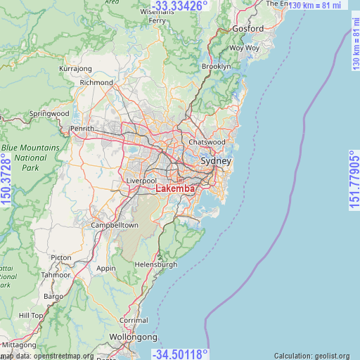
Lakemba GPS coordinates[2]
33° 55' 10.992" South, 151° 4' 33.312" East
| Map corner | latitude | longitude |
|---|---|---|
| Upper-left | -33.33426°, | 150.3728° |
| Center: | -33.91972°, | 151.07592° |
| Lower-right: | -34.50118°, | 151.77905° |
| Map W x H: | 129.7×129.7 km | = 80.6×80.6mi |
| max Lat: | -10.58257° ⇑56.8% North |
| Lakemba: | -33.91972° |
| min Lat: | ⇓43.2% South -43.31423° |
| min Long | Lakemba | max Long |
| 113.53327° | 151.07592° | 153.61246° |
| W 69.2%⇐ | ⇒30.8% E |
Elevation
Elevation of Lakemba is 37 m = 121 ft, and this is 85 m = 279 ft below average elevation for this country.
| Max E: |
1715 m = 5627 ft | 55.9% |
| Avg. | 122 m = 400 ft | |
| Lakemba | 37 m = 121 ft | |
Min E: |
-2 m = -7 ft | 44.1% |
See also: Australia elevation on elevation.city.
Geographical zone
Lakemba is located in South temperate zone (between Tropic of Capricorn and the Antarctic Circle). Distance of this Southern Tropic circle is 1165.6 km =724.3 mi to North.| Distance of | km | miles | from Lakemba |
|---|---|---|---|
| Equator | 3771.5 | 2343.5 | to North |
| Tropic Capricorn | 1165.6 | 724.3 | to North |
| Antarctic Circle | 3629.7 | 2255.4 | to South |
| South Pole | 6235.5 | 3874.6 | to South |


Nearby cities:
15 places around Lakemba: (largest is in red/bold)
• Bankstown
3.9 km =2.4 mi,  274°
274°
• Belfield
2 km =1.2 mi,  24°
24°
• Belmore
1.2 km =0.7 mi,  86°
86°
• Beverly Hills
3.2 km =2 mi,  173°
173°
• Campsie
2.6 km =1.6 mi,  72°
72°
• Clemton Park
2.7 km =1.7 mi,  105°
105°
• Greenacre
2.9 km =1.8 mi,  319°
319°
• Kingsgrove
3.1 km =1.9 mi,  135°
135°
• Mount Lewis
2.6 km =1.6 mi,  275°
275°
• Narwee
3 km =1.9 mi,  191°
191°
• Punchbowl
2.5 km =1.6 mi,  245°
245°
• Riverwood
3.9 km =2.4 mi,  218°
218°
• Roselands
1.5 km =0.9 mi, 189°
• Strathfield South
3.1 km =1.9 mi,  12°
12°
• Wiley Park
0.9 km =0.6 mi,  237°
237°
Sources, notices
• [Note1] Compared only with cities in Australia existing in our database
• [Src1] Map data: © OpenStreetMap contributors (CC-BY-SA)
• [Src2] Other city data from geonames.org with taken over terms of usage.
• [Src3] Geographical zone / Annual Mean Temperature by Robert A. Rohde @ Wikipedia
