Belfield geodata
Belfield (New South Wales) is a section of populated place; located in Australia in Australia/Sydney (GMT+11) time zone. With population of 6,295 people, there are 1131 cities with bigger population in this country. Compared to other cities in Australia, 56.2% of cities are located further ↑North; 69.5% of cities are located further ←West and 68.6% of cities have higher elevation than Belfield. Note1


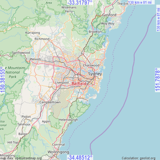
Belfield GPS coordinates[2]
33° 54' 12.744" South, 151° 5' 4.812" East
| Map corner | latitude | longitude |
|---|---|---|
| Upper-left | -33.31797°, | 150.38155° |
| Center: | -33.90354°, | 151.08467° |
| Lower-right: | -34.48512°, | 151.7878° |
| Map W x H: | 129.8×129.8 km | = 80.7×80.7mi |
| max Lat: | -10.58257° ⇑56.2% North |
| Belfield: | -33.90354° |
| min Lat: | ⇓43.8% South -43.31423° |
| min Long | Belfield | max Long |
| 113.53327° | 151.08467° | 153.61246° |
| W 69.5%⇐ | ⇒30.5% E |
Elevation
Elevation of Belfield is 24 m = 79 ft, and this is 98 m = 322 ft below average elevation for this country.
| Max E: |
1715 m = 5627 ft | 68.6% |
| Avg. | 122 m = 400 ft | |
| Belfield | 24 m = 79 ft | |
Min E: |
-2 m = -7 ft | 31.4% |
See also: Australia elevation on elevation.city.
Geographical zone
Belfield is located in South temperate zone (between Tropic of Capricorn and the Antarctic Circle). Distance of this Southern Tropic circle is 1163.8 km =723.2 mi to North.| Distance of | km | miles | from Belfield |
|---|---|---|---|
| Equator | 3769.7 | 2342.4 | to North |
| Tropic Capricorn | 1163.8 | 723.2 | to North |
| Antarctic Circle | 3631.5 | 2256.5 | to South |
| South Pole | 6237.3 | 3875.7 | to South |


Nearby cities:
15 places around Belfield: (largest is in red/bold)
• Ashbury
3.3 km =2.1 mi,  78°
78°
• Belmore
1.8 km =1.1 mi,  165°
165°
• Burwood
2.7 km =1.7 mi,  32°
32°
• Burwood Heights
2.4 km =1.5 mi,  48°
48°
• Campsie
1.9 km =1.2 mi,  120°
120°
• Canterbury
3.3 km =2.1 mi,  106°
106°
• Clemton Park
3.1 km =1.9 mi,  144°
144°
• Croydon
3.7 km =2.3 mi, 52°
• Greenacre
2.7 km =1.7 mi,  277°
277°
• Lakemba
2 km =1.2 mi,  204°
204°
• Mount Lewis
3.7 km =2.3 mi,  245°
245°
• Roselands
3.5 km =2.2 mi, 197°
• Strathfield
2.5 km =1.6 mi,  349°
349°
• Strathfield South
1.2 km =0.7 mi, 354°
• Wiley Park
2.8 km =1.7 mi,  214°
214°
Sources, notices
• [Note1] Compared only with cities in Australia existing in our database
• [Src1] Map data: © OpenStreetMap contributors (CC-BY-SA)
• [Src2] Other city data from geonames.org with taken over terms of usage.
• [Src3] Geographical zone / Annual Mean Temperature by Robert A. Rohde @ Wikipedia
