Greenacre geodata
Greenacre (New South Wales) is a section of populated place; located in Australia in Australia/Sydney (GMT+11) time zone. With population of 24,361 people, there are 108 cities with bigger population in this country. Compared to other cities in Australia, 56.1% of cities are located further ↑North; 68.8% of cities are located further ←West and 58.4% of cities have higher elevation than Greenacre. Note1


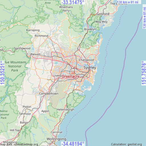
Greenacre GPS coordinates[2]
33° 54' 1.224" South, 151° 3' 20.268" East
| Map corner | latitude | longitude |
|---|---|---|
| Upper-left | -33.31475°, | 150.35251° |
| Center: | -33.90034°, | 151.05563° |
| Lower-right: | -34.48194°, | 151.75876° |
| Map W x H: | 129.8×129.8 km | = 80.7×80.7mi |
| max Lat: | -10.58257° ⇑56.1% North |
| Greenacre: | -33.90034° |
| min Lat: | ⇓43.9% South -43.31423° |
| min Long | Greenacre | max Long |
| 113.53327° | 151.05563° | 153.61246° |
| W 68.8%⇐ | ⇒31.2% E |
Elevation
Elevation of Greenacre is 34 m = 112 ft, and this is 88 m = 289 ft below average elevation for this country.
| Max E: |
1715 m = 5627 ft | 58.4% |
| Avg. | 122 m = 400 ft | |
| Greenacre | 34 m = 112 ft | |
Min E: |
-2 m = -7 ft | 41.6% |
See also: Australia elevation on elevation.city.
Geographical zone
Greenacre is located in South temperate zone (between Tropic of Capricorn and the Antarctic Circle). Distance of this Southern Tropic circle is 1163.4 km =722.9 mi to North.| Distance of | km | miles | from Greenacre |
|---|---|---|---|
| Equator | 3769.4 | 2342.2 | to North |
| Tropic Capricorn | 1163.4 | 722.9 | to North |
| Antarctic Circle | 3631.8 | 2256.7 | to South |
| South Pole | 6237.7 | 3875.9 | to South |


Nearby cities:
15 places around Greenacre: (largest is in red/bold)
• Bankstown
2.7 km =1.7 mi,  228°
228°
• Belfield
2.7 km =1.7 mi,  97°
97°
• Belmore
3.7 km =2.3 mi,  123°
123°
• Berala
3.7 km =2.3 mi,  327°
327°
• Birrong
3.3 km =2.1 mi,  285°
285°
• Lakemba
2.9 km =1.8 mi,  139°
139°
• Mount Lewis
2 km =1.2 mi,  199°
199°
• Potts Hill
2.2 km =1.4 mi, 291°
• Punchbowl
3.2 km =2 mi,  187°
187°
• Regents Park
4.1 km =2.5 mi,  297°
297°
• Roselands
4 km =2.5 mi,  156°
156°
• Strathfield
3.1 km =1.9 mi,  46°
46°
• Strathfield South
2.7 km =1.7 mi,  71°
71°
• Wiley Park
2.9 km =1.8 mi, 157°
• Yagoona
3.3 km =2.1 mi,  261°
261°
Sources, notices
• [Note1] Compared only with cities in Australia existing in our database
• [Src1] Map data: © OpenStreetMap contributors (CC-BY-SA)
• [Src2] Other city data from geonames.org with taken over terms of usage.
• [Src3] Geographical zone / Annual Mean Temperature by Robert A. Rohde @ Wikipedia
