Bassendean geodata
Bassendean (Western Australia) is a section of populated place; located in Australia in Australia/Perth (GMT+8) time zone. With population of 10,141 people, there are 583 cities with bigger population in this country. Compared to other cities in Australia, 66.5% of cities are located further ↓South; 93.2% of cities are located further →East and 74.7% of cities have higher elevation than Bassendean. Note1


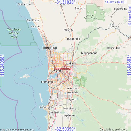
Bassendean GPS coordinates[2]
31° 54' 32.616" South, 115° 56' 37.32" East
| Map corner | latitude | longitude |
|---|---|---|
| Upper-left | -31.31026°, | 115.24058° |
| Center: | -31.90906°, | 115.9437° |
| Lower-right: | -32.50399°, | 116.64683° |
| Map W x H: | 132.7×132.7 km | = 82.5×82.5mi |
| max Lat: | -10.58257° ⇑33.5% North |
| Bassendean: | -31.90906° |
| min Lat: | ⇓66.5% South -43.31423° |
| min Long | Bassendean | max Long |
| 113.53327° | 115.9437° | 153.61246° |
| W 6.8%⇐ | ⇒93.2% E |
Elevation
Elevation of Bassendean is 19 m = 62 ft, and this is 103 m = 338 ft below average elevation for this country.
| Max E: |
1715 m = 5627 ft | 74.7% |
| Avg. | 122 m = 400 ft | |
| Bassendean | 19 m = 62 ft | |
Min E: |
-2 m = -7 ft | 25.3% |
See also: Australia elevation on elevation.city.
Geographical zone
Bassendean is located in South temperate zone (between Tropic of Capricorn and the Antarctic Circle). Distance of this Southern Tropic circle is 942 km =585.3 mi to North.| Distance of | km | miles | from Bassendean |
|---|---|---|---|
| Equator | 3548 | 2204.6 | to North |
| Tropic Capricorn | 942 | 585.3 | to North |
| Antarctic Circle | 3853.2 | 2394.3 | to South |
| South Pole | 6459.1 | 4013.5 | to South |


Nearby cities:
15 places around Bassendean: (largest is in red/bold)
• Ascot
3.8 km =2.4 mi,  211°
211°
• Ashfield
1.1 km =0.7 mi, 210°
• Bayswater
2.6 km =1.6 mi,  250°
250°
• Beechboro
4.9 km =3 mi,  352°
352°
• Belmont
4.2 km =2.6 mi,  204°
204°
• Caversham
3.6 km =2.2 mi,  37°
37°
• Eden Hill
2.2 km =1.4 mi,  7°
7°
• Embleton
3.3 km =2.1 mi,  280°
280°
• Guildford
2.4 km =1.5 mi,  65°
65°
• Kiara
3.1 km =1.9 mi, 351°
• Lockridge
3.1 km =1.9 mi, 11°
• Morley
4 km =2.5 mi,  306°
306°
• Redcliffe
3.3 km =2.1 mi,  175°
175°
• South Guildford
2.3 km =1.4 mi,  98°
98°
• Woodbridge
5.2 km =3.2 mi,  61°
61°
Sources, notices
• [Note1] Compared only with cities in Australia existing in our database
• [Src1] Map data: © OpenStreetMap contributors (CC-BY-SA)
• [Src2] Other city data from geonames.org with taken over terms of usage.
• [Src3] Geographical zone / Annual Mean Temperature by Robert A. Rohde @ Wikipedia
