Eastgardens geodata
Eastgardens (New South Wales) is a section of populated place; located in Australia in Australia/Sydney (GMT+11) time zone. With population of 873 people, there are 4013 cities with bigger population in this country. Compared to other cities in Australia, 57.6% of cities are located further ↑North; 74% of cities are located further ←West and 58.4% of cities have higher elevation than Eastgardens. Note1


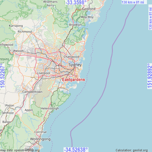
Eastgardens GPS coordinates[2]
33° 56' 42.324" South, 151° 13' 32.844" East
| Map corner | latitude | longitude |
|---|---|---|
| Upper-left | -33.3598°, | 150.52267° |
| Center: | -33.94509°, | 151.22579° |
| Lower-right: | -34.52638°, | 151.92892° |
| Map W x H: | 129.7×129.7 km | = 80.6×80.6mi |
| max Lat: | -10.58257° ⇑57.6% North |
| Eastgardens: | -33.94509° |
| min Lat: | ⇓42.4% South -43.31423° |
| min Long | Eastgardens | max Long |
| 113.53327° | 151.22579° | 153.61246° |
| W 74%⇐ | ⇒26% E |
Elevation
Elevation of Eastgardens is 34 m = 112 ft, and this is 88 m = 289 ft below average elevation for this country.
| Max E: |
1715 m = 5627 ft | 58.4% |
| Avg. | 122 m = 400 ft | |
| Eastgardens | 34 m = 112 ft | |
Min E: |
-2 m = -7 ft | 41.6% |
See also: Australia elevation on elevation.city.
Geographical zone
Eastgardens is located in South temperate zone (between Tropic of Capricorn and the Antarctic Circle). Distance of this Southern Tropic circle is 1168.4 km =726 mi to North.| Distance of | km | miles | from Eastgardens |
|---|---|---|---|
| Equator | 3774.3 | 2345.2 | to North |
| Tropic Capricorn | 1168.4 | 726 | to North |
| Antarctic Circle | 3626.8 | 2253.6 | to South |
| South Pole | 6232.7 | 3872.8 | to South |


Nearby cities:
15 places around Eastgardens: (largest is in red/bold)
• Botany
2.8 km =1.7 mi,  267°
267°
• Chifley
2.9 km =1.8 mi,  148°
148°
• Coogee
3.9 km =2.4 mi,  44°
44°
• Daceyville
1.8 km =1.1 mi,  359°
359°
• Eastlakes
1.9 km =1.2 mi,  319°
319°
• Hillsdale
0.7 km =0.4 mi,  165°
165°
• Kensington
2.8 km =1.7 mi,  353°
353°
• Kingsford
2.4 km =1.5 mi,  3°
3°
• Malabar
2.8 km =1.7 mi,  132°
132°
• Maroubra
0.9 km =0.6 mi, 128°
• Mascot
3.7 km =2.3 mi,  305°
305°
• Matraville
2.1 km =1.3 mi,  164°
164°
• Pagewood
1.4 km =0.9 mi,  286°
286°
• Randwick
4 km =2.5 mi,  32°
32°
• South Coogee
3.2 km =2 mi,  60°
60°
Sources, notices
• [Note1] Compared only with cities in Australia existing in our database
• [Src1] Map data: © OpenStreetMap contributors (CC-BY-SA)
• [Src2] Other city data from geonames.org with taken over terms of usage.
• [Src3] Geographical zone / Annual Mean Temperature by Robert A. Rohde @ Wikipedia
