Coogee geodata
Coogee (New South Wales) is a section of populated place; located in Australia in Australia/Sydney (GMT+11) time zone. With population of 15,333 people, there are 263 cities with bigger population in this country. Compared to other cities in Australia, 56.8% of cities are located further ↑North; 74.7% of cities are located further ←West and 76.1% of cities have higher elevation than Coogee. Note1


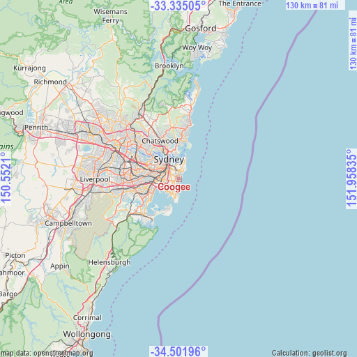
Coogee GPS coordinates[2]
33° 55' 13.8" South, 151° 15' 18.792" East
| Map corner | latitude | longitude |
|---|---|---|
| Upper-left | -33.33505°, | 150.5521° |
| Center: | -33.9205°, | 151.25522° |
| Lower-right: | -34.50196°, | 151.95835° |
| Map W x H: | 129.7×129.7 km | = 80.6×80.6mi |
| max Lat: | -10.58257° ⇑56.8% North |
| Coogee: | -33.9205° |
| min Lat: | ⇓43.2% South -43.31423° |
| min Long | Coogee | max Long |
| 113.53327° | 151.25522° | 153.61246° |
| W 74.7%⇐ | ⇒25.3% E |
Elevation
Elevation of Coogee is 18 m = 59 ft, and this is 104 m = 341 ft below average elevation for this country.
| Max E: |
1715 m = 5627 ft | 76.1% |
| Avg. | 122 m = 400 ft | |
| Coogee | 18 m = 59 ft | |
Min E: |
-2 m = -7 ft | 23.9% |
See also: Australia elevation on elevation.city.
Geographical zone
Coogee is located in South temperate zone (between Tropic of Capricorn and the Antarctic Circle). Distance of this Southern Tropic circle is 1165.7 km =724.3 mi to North.| Distance of | km | miles | from Coogee |
|---|---|---|---|
| Equator | 3771.6 | 2343.6 | to North |
| Tropic Capricorn | 1165.7 | 724.3 | to North |
| Antarctic Circle | 3629.6 | 2255.3 | to South |
| South Pole | 6235.5 | 3874.6 | to South |


Nearby cities:
15 places around Coogee: (largest is in red/bold)
• Bondi
3 km =1.9 mi,  16°
16°
• Bondi Beach
3.9 km =2.4 mi,  33°
33°
• Bondi Junction
3.2 km =2 mi,  346°
346°
• Bronte
2.3 km =1.4 mi, 24°
• Centennial Park
3.2 km =2 mi,  321°
321°
• Clovelly
1 km =0.6 mi, 19°
• Daceyville
2.9 km =1.8 mi,  251°
251°
• Eastgardens
3.9 km =2.4 mi,  224°
224°
• Kensington
3 km =1.9 mi,  270°
270°
• Kingsford
2.6 km =1.6 mi,  261°
261°
• Maroubra
3.9 km =2.4 mi,  211°
211°
• Queens Park
2.5 km =1.6 mi,  342°
342°
• Randwick
0.9 km =0.6 mi, 319°
• South Coogee
1.2 km =0.7 mi,  176°
176°
• Tamarama
2.8 km =1.7 mi, 29°
Sources, notices
• [Note1] Compared only with cities in Australia existing in our database
• [Src1] Map data: © OpenStreetMap contributors (CC-BY-SA)
• [Src2] Other city data from geonames.org with taken over terms of usage.
• [Src3] Geographical zone / Annual Mean Temperature by Robert A. Rohde @ Wikipedia
