Rosemeadow geodata
Rosemeadow (New South Wales) is a section of populated place; located in Australia in Australia/Sydney (GMT+11) time zone. With population of 7,756 people, there are 868 cities with bigger population in this country. Compared to other cities in Australia, 60.8% of cities are located further ↑North; 62.2% of cities are located further ←West and 77.6% of cities have lower elevation than Rosemeadow. Note1


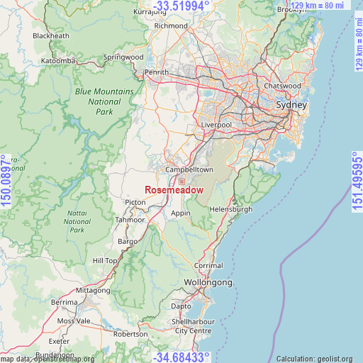
Rosemeadow GPS coordinates[2]
34° 6' 14.904" South, 150° 47' 34.152" East
| Map corner | latitude | longitude |
|---|---|---|
| Upper-left | -33.51994°, | 150.0897° |
| Center: | -34.10414°, | 150.79282° |
| Lower-right: | -34.68433°, | 151.49595° |
| Map W x H: | 129.5×129.5 km | = 80.5×80.5mi |
| max Lat: | -10.58257° ⇑60.8% North |
| Rosemeadow: | -34.10414° |
| min Lat: | ⇓39.2% South -43.31423° |
| min Long | Rosemeadow | max Long |
| 113.53327° | 150.79282° | 153.61246° |
| W 62.2%⇐ | ⇒37.8% E |
Elevation
Elevation of Rosemeadow is 152 m = 499 ft, and this is 30 m = 98 ft above average elevation for this country.
| Max E: |
1715 m = 5627 ft | 22.4% |
| Rosemeadow | 152 m 499 ft | |
| Avg. | 122 m = 400 ft | |
Min E: |
-2 m = -7 ft | 77.6% |
See also: Australia elevation on elevation.city.
Geographical zone
Rosemeadow is located in South temperate zone (between Tropic of Capricorn and the Antarctic Circle). Distance of this Southern Tropic circle is 1186.1 km =737 mi to North.| Distance of | km | miles | from Rosemeadow |
|---|---|---|---|
| Equator | 3792 | 2356.2 | to North |
| Tropic Capricorn | 1186.1 | 737 | to North |
| Antarctic Circle | 3609.1 | 2242.6 | to South |
| South Pole | 6215 | 3861.8 | to South |


Nearby cities:
15 places around Rosemeadow: (largest is in red/bold)
• Airds
4.2 km =2.6 mi,  61°
61°
• Ambarvale
1.7 km =1.1 mi,  11°
11°
• Blair Athol
4.7 km =2.9 mi, 9°
• Bradbury
2.9 km =1.8 mi,  44°
44°
• Campbelltown
4.7 km =2.9 mi,  27°
27°
• Claymore
6.6 km =4.1 mi, 14°
• Currans Hill
7 km =4.3 mi,  344°
344°
• Glen Alpine
2.1 km =1.3 mi, 340°
• Leumeah
7.1 km =4.4 mi, 31°
• Menangle
5.6 km =3.5 mi,  243°
243°
• Mount Annan
6.5 km =4 mi,  331°
331°
• Ruse
5.9 km =3.7 mi,  49°
49°
• St Helens Park
1.9 km =1.2 mi,  91°
91°
• Wedderburn
3.9 km =2.4 mi,  145°
145°
• Woodbine
7 km =4.3 mi,  22°
22°
Sources, notices
• [Note1] Compared only with cities in Australia existing in our database
• [Src1] Map data: © OpenStreetMap contributors (CC-BY-SA)
• [Src2] Other city data from geonames.org with taken over terms of usage.
• [Src3] Geographical zone / Annual Mean Temperature by Robert A. Rohde @ Wikipedia
