Menangle geodata
Menangle (New South Wales) is a populated place; located in Australia in Australia/Sydney (GMT+11) time zone. With population of 1,144 people, there are 3648 cities with bigger population in this country. Compared to other cities in Australia, 60.9% of cities are located further ↑North; 61.3% of cities are located further ←West and 67.3% of cities have lower elevation than Menangle. Note1


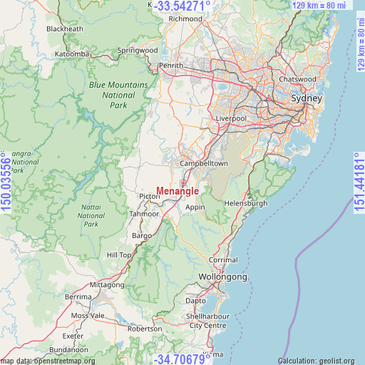
Menangle GPS coordinates[2]
34° 7' 36.3" South, 150° 44' 19.248" East
| Map corner | latitude | longitude |
|---|---|---|
| Upper-left | -33.54271°, | 150.03556° |
| Center: | -34.12675°, | 150.73868° |
| Lower-right: | -34.70679°, | 151.44181° |
| Map W x H: | 129.4×129.4 km | = 80.4×80.4mi |
| max Lat: | -10.58257° ⇑60.9% North |
| Menangle: | -34.12675° |
| min Lat: | ⇓39.1% South -43.31423° |
| min Long | Menangle | max Long |
| 113.53327° | 150.73868° | 153.61246° |
| W 61.3%⇐ | ⇒38.7% E |
Elevation
Elevation of Menangle is 90 m = 295 ft, and this is 32 m = 105 ft below average elevation for this country.
| Max E: |
1715 m = 5627 ft | 32.7% |
| Avg. | 122 m = 400 ft | |
| Menangle | 90 m = 295 ft | |
Min E: |
-2 m = -7 ft | 67.3% |
See also: Australia elevation on elevation.city.
Geographical zone
Menangle is located in South temperate zone (between Tropic of Capricorn and the Antarctic Circle). Distance of this Southern Tropic circle is 1188.6 km =738.6 mi to North.| Distance of | km | miles | from Menangle |
|---|---|---|---|
| Equator | 3794.5 | 2357.8 | to North |
| Tropic Capricorn | 1188.6 | 738.6 | to North |
| Antarctic Circle | 3606.6 | 2241 | to South |
| South Pole | 6212.5 | 3860.3 | to South |


Nearby cities:
15 places around Menangle: (largest is in red/bold)
• Ambarvale
6.8 km =4.2 mi,  52°
52°
• Blair Athol
9.2 km =5.7 mi,  38°
38°
• Bradbury
8.4 km =5.2 mi,  56°
56°
• Camden
9 km =5.6 mi,  334°
334°
• Camden South
6.3 km =3.9 mi,  320°
320°
• Douglas Park
6.8 km =4.2 mi,  198°
198°
• Elderslie
8.3 km =5.2 mi,  343°
343°
• Glen Alpine
6.2 km =3.9 mi, 43°
• Mount Annan
8.4 km =5.2 mi,  13°
13°
• Narellan Vale
8.6 km =5.3 mi,  3°
3°
• Razorback
8.4 km =5.2 mi,  250°
250°
• Rosemeadow
5.6 km =3.5 mi, 63°
• Spring Farm
6.9 km =4.3 mi, 339°
• St Helens Park
7.3 km =4.5 mi,  70°
70°
• Wedderburn
7.2 km =4.5 mi,  95°
95°
Sources, notices
• [Note1] Compared only with cities in Australia existing in our database
• [Src1] Map data: © OpenStreetMap contributors (CC-BY-SA)
• [Src2] Other city data from geonames.org with taken over terms of usage.
• [Src3] Geographical zone / Annual Mean Temperature by Robert A. Rohde @ Wikipedia
