Burdell geodata
Burdell (Queensland) is a section of populated place; located in Australia in Australia/Brisbane (GMT+10) time zone. With population of 5,539 people, there are 1337 cities with bigger population in this country. Compared to other cities in Australia, 95.5% of cities are located further ↓South; 54.8% of cities are located further →East and 90.1% of cities have higher elevation than Burdell. Note1


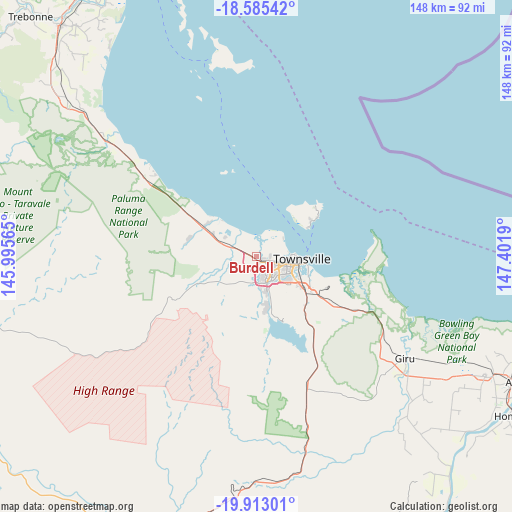
Burdell GPS coordinates[2]
19° 15' 2.016" South, 146° 41' 55.572" East
| Map corner | latitude | longitude |
|---|---|---|
| Upper-left | -18.58542°, | 145.99565° |
| Center: | -19.25056°, | 146.69877° |
| Lower-right: | -19.91301°, | 147.4019° |
| Map W x H: | 147.6×147.6 km | = 91.7×91.7mi |
| max Lat: | -10.58257° ⇑4.5% North |
| Burdell: | -19.25056° |
| min Lat: | ⇓95.5% South -43.31423° |
| min Long | Burdell | max Long |
| 113.53327° | 146.69877° | 153.61246° |
| W 45.2%⇐ | ⇒54.8% E |
Elevation
Elevation of Burdell is 9 m = 30 ft, and this is 113 m = 371 ft below average elevation for this country.
| Max E: |
1715 m = 5627 ft | 90.1% |
| Avg. | 122 m = 400 ft | |
| Burdell | 9 m = 30 ft | |
Min E: |
-2 m = -7 ft | 9.9% |
See also: Australia elevation on elevation.city.
Geographical zone
Burdell is located in South Torrid zone (between Equator and Tropic of Capricorn). Distance of this Southern Tropic circle is 465.5 km =289.2 mi to South.| Distance of | km | miles | from Burdell |
|---|---|---|---|
| Equator | 2140.5 | 1330 | to North |
| Tropic Capricorn | 465.5 | 289.2 | to South |
| Antarctic Circle | 5260.7 | 3268.8 | to South |
| South Pole | 7866.6 | 4888.1 | to South |


Nearby cities:
15 places around Burdell: (largest is in red/bold)
• Black River
8.9 km =5.5 mi,  288°
288°
• Bohle Plains
7.1 km =4.4 mi,  185°
185°
• Bushland Beach
7 km =4.3 mi,  340°
340°
• Condon
9 km =5.6 mi,  167°
167°
• Cranbrook
8.3 km =5.2 mi,  137°
137°
• Currajong
8.9 km =5.5 mi,  108°
108°
• Deeragun
2.4 km =1.5 mi,  278°
278°
• Garbutt
8.9 km =5.5 mi,  101°
101°
• Heatley
7.3 km =4.5 mi,  127°
127°
• Jensen
4.8 km =3 mi, 276°
• Kirwan
6.5 km =4 mi,  154°
154°
• Mount Louisa
6.1 km =3.8 mi,  115°
115°
• Mount Low
3.7 km =2.3 mi,  303°
303°
• Shaw
1.4 km =0.9 mi,  160°
160°
• Vincent
7.8 km =4.8 mi, 117°
Sources, notices
• [Note1] Compared only with cities in Australia existing in our database
• [Src1] Map data: © OpenStreetMap contributors (CC-BY-SA)
• [Src2] Other city data from geonames.org with taken over terms of usage.
• [Src3] Geographical zone / Annual Mean Temperature by Robert A. Rohde @ Wikipedia
