Black River geodata
Black River (Queensland) is a section of populated place; located in Australia in Australia/Brisbane (GMT+10) time zone. With population of 1,485 people, there are 3292 cities with bigger population in this country. Compared to other cities in Australia, 95.7% of cities are located further ↓South; 55.1% of cities are located further →East and 79% of cities have higher elevation than Black River. Note1


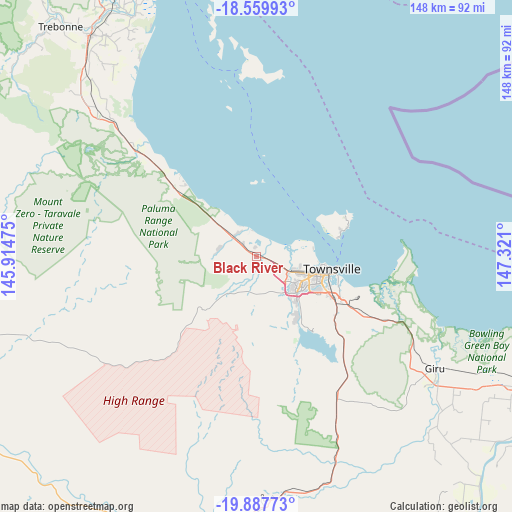
Black River GPS coordinates[2]
19° 13' 30.612" South, 146° 37' 4.332" East
| Map corner | latitude | longitude |
|---|---|---|
| Upper-left | -18.55993°, | 145.91475° |
| Center: | -19.22517°, | 146.61787° |
| Lower-right: | -19.88773°, | 147.321° |
| Map W x H: | 147.6×147.6 km | = 91.7×91.7mi |
| max Lat: | -10.58257° ⇑4.3% North |
| Black River: | -19.22517° |
| min Lat: | ⇓95.7% South -43.31423° |
| min Long | Black River | max Long |
| 113.53327° | 146.61787° | 153.61246° |
| W 44.9%⇐ | ⇒55.1% E |
Elevation
Elevation of Black River is 16 m = 52 ft, and this is 106 m = 348 ft below average elevation for this country.
| Max E: |
1715 m = 5627 ft | 79% |
| Avg. | 122 m = 400 ft | |
| Black River | 16 m = 52 ft | |
Min E: |
-2 m = -7 ft | 21% |
See also: Australia elevation on elevation.city.
Geographical zone
Black River is located in South Torrid zone (between Equator and Tropic of Capricorn). Distance of this Southern Tropic circle is 468.3 km =291 mi to South.| Distance of | km | miles | from Black River |
|---|---|---|---|
| Equator | 2137.6 | 1328.2 | to North |
| Tropic Capricorn | 468.3 | 291 | to South |
| Antarctic Circle | 5263.5 | 3270.6 | to South |
| South Pole | 7869.4 | 4889.8 | to South |


Nearby cities:
15 places around Black River: (largest is in red/bold)
• Alice River
12.1 km =7.5 mi,  181°
181°
• Bluewater
7.9 km =4.9 mi,  307°
307°
• Bluewater Park
11.2 km =7 mi,  281°
281°
• Bohle Plains
12.5 km =7.8 mi,  141°
141°
• Burdell
8.9 km =5.5 mi,  108°
108°
• Bushland Beach
7.2 km =4.5 mi,  58°
58°
• Condon
15.6 km =9.7 mi, 138°
• Deeragun
6.6 km =4.1 mi, 112°
• Jensen
4.3 km =2.7 mi,  121°
121°
• Kirwan
14.2 km =8.8 mi,  127°
127°
• Mount Louisa
15 km =9.3 mi, 111°
• Mount Low
5.5 km =3.4 mi,  98°
98°
• Rangewood
9.8 km =6.1 mi,  167°
167°
• Shaw
9.9 km =6.2 mi, 114°
• Yabulu
4.1 km =2.5 mi, 311°
Sources, notices
• [Note1] Compared only with cities in Australia existing in our database
• [Src1] Map data: © OpenStreetMap contributors (CC-BY-SA)
• [Src2] Other city data from geonames.org with taken over terms of usage.
• [Src3] Geographical zone / Annual Mean Temperature by Robert A. Rohde @ Wikipedia
