Warana geodata
Warana (Queensland) is a section of populated place; located in Australia in Australia/Brisbane (GMT+10) time zone. With population of 3,604 people, there are 1955 cities with bigger population in this country. Compared to other cities in Australia, 86.5% of cities are located further ↓South; 95.5% of cities are located further ←West and 98.1% of cities have higher elevation than Warana. Note1


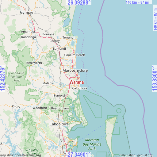
Warana GPS coordinates[2]
26° 43' 21.828" South, 153° 7' 36.768" East
| Map corner | latitude | longitude |
|---|---|---|
| Upper-left | -26.09298°, | 152.42376° |
| Center: | -26.72273°, | 153.12688° |
| Lower-right: | -27.34901°, | 153.83001° |
| Map W x H: | 139.7×139.7 km | = 86.8×86.8mi |
| max Lat: | -10.58257° ⇑13.5% North |
| Warana: | -26.72273° |
| min Lat: | ⇓86.5% South -43.31423° |
| min Long | Warana | max Long |
| 113.53327° | 153.12688° | 153.61246° |
| W 95.5%⇐ | ⇒4.5% E |
Elevation
Elevation of Warana is 4 m = 13 ft, and this is 118 m = 387 ft below average elevation for this country.
| Max E: |
1715 m = 5627 ft | 98.1% |
| Avg. | 122 m = 400 ft | |
| Warana | 4 m = 13 ft | |
Min E: |
-2 m = -7 ft | 1.9% |
See also: Australia elevation on elevation.city.
Geographical zone
Warana is located in South temperate zone (between Tropic of Capricorn and the Antarctic Circle). Distance of this Southern Tropic circle is 365.4 km =227 mi to North.| Distance of | km | miles | from Warana |
|---|---|---|---|
| Equator | 2971.3 | 1846.3 | to North |
| Tropic Capricorn | 365.4 | 227 | to North |
| Antarctic Circle | 4429.9 | 2752.6 | to South |
| South Pole | 7035.8 | 4371.8 | to South |


Nearby cities:
15 places around Warana: (largest is in red/bold)
• Alexandra Headland
6.3 km =3.9 mi,  335°
335°
• Aroona
6.6 km =4.1 mi,  188°
188°
• Battery Hill
6.2 km =3.9 mi,  178°
178°
• Birtinya
2.4 km =1.5 mi,  198°
198°
• Bokarina
1.8 km =1.1 mi,  168°
168°
• Buddina
3.1 km =1.9 mi,  11°
11°
• Currimundi
5.2 km =3.2 mi, 184°
• Dicky Beach
6.9 km =4.3 mi, 171°
• Minyama
3 km =1.9 mi,  353°
353°
• Mooloolaba
4.6 km =2.9 mi, 350°
• Mountain Creek
3.4 km =2.1 mi,  311°
311°
• Palmview
7.1 km =4.4 mi,  248°
248°
• Parrearra
1.3 km =0.8 mi, 338°
• Sippy Downs
7.2 km =4.5 mi,  274°
274°
• Wurtulla
3.8 km =2.4 mi, 178°
Sources, notices
• [Note1] Compared only with cities in Australia existing in our database
• [Src1] Map data: © OpenStreetMap contributors (CC-BY-SA)
• [Src2] Other city data from geonames.org with taken over terms of usage.
• [Src3] Geographical zone / Annual Mean Temperature by Robert A. Rohde @ Wikipedia
