Palmview geodata
Palmview (Queensland) is a section of populated place; located in Australia in Australia/Brisbane (GMT+10) time zone. With population of 856 people, there are 4053 cities with bigger population in this country. Compared to other cities in Australia, 86.3% of cities are located further ↓South; 93.4% of cities are located further ←West and 86.8% of cities have higher elevation than Palmview. Note1


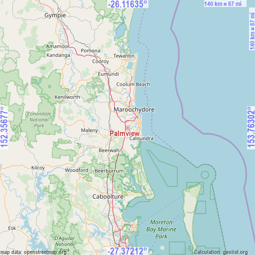
Palmview GPS coordinates[2]
26° 44' 45.492" South, 153° 3' 35.604" East
| Map corner | latitude | longitude |
|---|---|---|
| Upper-left | -26.11635°, | 152.35677° |
| Center: | -26.74597°, | 153.05989° |
| Lower-right: | -27.37212°, | 153.76302° |
| Map W x H: | 139.6×139.6 km | = 86.7×86.7mi |
| max Lat: | -10.58257° ⇑13.7% North |
| Palmview: | -26.74597° |
| min Lat: | ⇓86.3% South -43.31423° |
| min Long | Palmview | max Long |
| 113.53327° | 153.05989° | 153.61246° |
| W 93.4%⇐ | ⇒6.6% E |
Elevation
Elevation of Palmview is 11 m = 36 ft, and this is 111 m = 364 ft below average elevation for this country.
| Max E: |
1715 m = 5627 ft | 86.8% |
| Avg. | 122 m = 400 ft | |
| Palmview | 11 m = 36 ft | |
Min E: |
-2 m = -7 ft | 13.2% |
See also: Australia elevation on elevation.city.
Geographical zone
Palmview is located in South temperate zone (between Tropic of Capricorn and the Antarctic Circle). Distance of this Southern Tropic circle is 368 km =228.7 mi to North.| Distance of | km | miles | from Palmview |
|---|---|---|---|
| Equator | 2973.9 | 1847.9 | to North |
| Tropic Capricorn | 368 | 228.7 | to North |
| Antarctic Circle | 4427.3 | 2751 | to South |
| South Pole | 7033.2 | 4370.2 | to South |


Nearby cities:
15 places around Palmview: (largest is in red/bold)
• Aroona
6.9 km =4.3 mi,  125°
125°
• Birtinya
5.9 km =3.7 mi,  87°
87°
• Bokarina
7.1 km =4.4 mi,  83°
83°
• Buderim
6.8 km =4.2 mi,  357°
357°
• Currimundi
6.7 km =4.2 mi,  112°
112°
• Glenview
4.9 km =3 mi,  241°
241°
• Ilkley
6.4 km =4 mi,  285°
285°
• Little Mountain
5.3 km =3.3 mi,  143°
143°
• Meridan Plains
3.1 km =1.9 mi,  176°
176°
• Mons
7 km =4.3 mi,  330°
330°
• Mountain Creek
6.3 km =3.9 mi,  40°
40°
• Sippy Downs
3.2 km =2 mi,  350°
350°
• Tanawha
4.1 km =2.5 mi,  314°
314°
• Warana
7.1 km =4.4 mi,  68°
68°
• Wurtulla
6.9 km =4.3 mi,  99°
99°
Sources, notices
• [Note1] Compared only with cities in Australia existing in our database
• [Src1] Map data: © OpenStreetMap contributors (CC-BY-SA)
• [Src2] Other city data from geonames.org with taken over terms of usage.
• [Src3] Geographical zone / Annual Mean Temperature by Robert A. Rohde @ Wikipedia
