Hillier geodata
Hillier (South Australia) is a section of populated place; located in Australia in Australia/Adelaide (GMT+10.5) time zone. With population of 671 people, there are 4381 cities with bigger population in this country. Compared to other cities in Australia, 64.3% of cities are located further ↑North; 79% of cities are located further →East and 53.1% of cities have higher elevation than Hillier. Note1


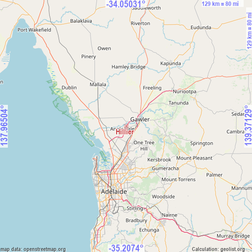
Hillier GPS coordinates[2]
34° 37' 51.132" South, 138° 40' 5.376" East
| Map corner | latitude | longitude |
|---|---|---|
| Upper-left | -34.05031°, | 137.96504° |
| Center: | -34.63087°, | 138.66816° |
| Lower-right: | -35.2074°, | 139.37129° |
| Map W x H: | 128.7×128.7 km | = 80×80mi |
| max Lat: | -10.58257° ⇑64.3% North |
| Hillier: | -34.63087° |
| min Lat: | ⇓35.7% South -43.31423° |
| min Long | Hillier | max Long |
| 113.53327° | 138.66816° | 153.61246° |
| W 21%⇐ | ⇒79% E |
Elevation
Elevation of Hillier is 41 m = 135 ft, and this is 81 m = 266 ft below average elevation for this country.
| Max E: |
1715 m = 5627 ft | 53.1% |
| Avg. | 122 m = 400 ft | |
| Hillier | 41 m = 135 ft | |
Min E: |
-2 m = -7 ft | 46.9% |
See also: Australia elevation on elevation.city.
Geographical zone
Hillier is located in South temperate zone (between Tropic of Capricorn and the Antarctic Circle). Distance of this Southern Tropic circle is 1244.7 km =773.4 mi to North.| Distance of | km | miles | from Hillier |
|---|---|---|---|
| Equator | 3850.6 | 2392.7 | to North |
| Tropic Capricorn | 1244.7 | 773.4 | to North |
| Antarctic Circle | 3550.6 | 2206.2 | to South |
| South Pole | 6156.5 | 3825.5 | to South |


Nearby cities:
15 places around Hillier: (largest is in red/bold)
• Andrews Farm
5.1 km =3.2 mi,  186°
186°
• Angle Vale
2.3 km =1.4 mi,  240°
240°
• Blakeview
6.3 km =3.9 mi,  142°
142°
• Davoren Park
6.6 km =4.1 mi,  179°
179°
• Evanston
6.2 km =3.9 mi,  75°
75°
• Evanston Gardens
5 km =3.1 mi, 80°
• Evanston Park
6.7 km =4.2 mi, 82°
• Gawler South
7.5 km =4.7 mi,  69°
69°
• Gawler West
6.6 km =4.1 mi,  63°
63°
• Kudla
3.3 km =2.1 mi,  112°
112°
• MacDonald Park
3.8 km =2.4 mi,  215°
215°
• Munno Para
5.1 km =3.2 mi, 143°
• Munno Para West
3.9 km =2.4 mi,  163°
163°
• Smithfield
6 km =3.7 mi,  166°
166°
• Smithfield Plains
5.1 km =3.2 mi, 170°
Sources, notices
• [Note1] Compared only with cities in Australia existing in our database
• [Src1] Map data: © OpenStreetMap contributors (CC-BY-SA)
• [Src2] Other city data from geonames.org with taken over terms of usage.
• [Src3] Geographical zone / Annual Mean Temperature by Robert A. Rohde @ Wikipedia
