Kudla geodata
Kudla (South Australia) is a section of populated place; located in Australia in Australia/Adelaide (GMT+10.5) time zone. With population of 509 people, there are 4856 cities with bigger population in this country. Compared to other cities in Australia, 64.4% of cities are located further ↑North; 78.1% of cities are located further →East and 52.4% of cities have higher elevation than Kudla. Note1


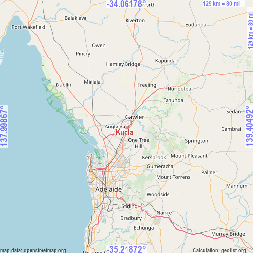
Kudla GPS coordinates[2]
34° 38' 32.172" South, 138° 42' 6.444" East
| Map corner | latitude | longitude |
|---|---|---|
| Upper-left | -34.06178°, | 137.99867° |
| Center: | -34.64227°, | 138.70179° |
| Lower-right: | -35.21872°, | 139.40492° |
| Map W x H: | 128.6×128.6 km | = 79.9×79.9mi |
| max Lat: | -10.58257° ⇑64.4% North |
| Kudla: | -34.64227° |
| min Lat: | ⇓35.6% South -43.31423° |
| min Long | Kudla | max Long |
| 113.53327° | 138.70179° | 153.61246° |
| W 21.9%⇐ | ⇒78.1% E |
Elevation
Elevation of Kudla is 42 m = 138 ft, and this is 80 m = 262 ft below average elevation for this country.
| Max E: |
1715 m = 5627 ft | 52.4% |
| Avg. | 122 m = 400 ft | |
| Kudla | 42 m = 138 ft | |
Min E: |
-2 m = -7 ft | 47.6% |
See also: Australia elevation on elevation.city.
Geographical zone
Kudla is located in South temperate zone (between Tropic of Capricorn and the Antarctic Circle). Distance of this Southern Tropic circle is 1245.9 km =774.2 mi to North.| Distance of | km | miles | from Kudla |
|---|---|---|---|
| Equator | 3851.9 | 2393.5 | to North |
| Tropic Capricorn | 1245.9 | 774.2 | to North |
| Antarctic Circle | 3549.3 | 2205.4 | to South |
| South Pole | 6155.2 | 3824.7 | to South |


Nearby cities:
15 places around Kudla: (largest is in red/bold)
• Andrews Farm
5.3 km =3.3 mi,  223°
223°
• Angle Vale
5.1 km =3.2 mi,  271°
271°
• Blakeview
3.8 km =2.4 mi,  168°
168°
• Evanston
4.1 km =2.5 mi,  45°
45°
• Evanston Gardens
2.8 km =1.7 mi,  40°
40°
• Evanston Park
4.2 km =2.6 mi,  59°
59°
• Gawler
6.2 km =3.9 mi, 44°
• Gawler South
5.5 km =3.4 mi, 44°
• Gawler West
5.1 km =3.2 mi,  33°
33°
• Hillier
3.3 km =2.1 mi,  292°
292°
• MacDonald Park
5.6 km =3.5 mi,  251°
251°
• Munno Para
2.9 km =1.8 mi,  180°
180°
• Munno Para West
3.1 km =1.9 mi, 217°
• Smithfield
4.9 km =3 mi,  200°
200°
• Smithfield Plains
4.4 km =2.7 mi,  209°
209°
Sources, notices
• [Note1] Compared only with cities in Australia existing in our database
• [Src1] Map data: © OpenStreetMap contributors (CC-BY-SA)
• [Src2] Other city data from geonames.org with taken over terms of usage.
• [Src3] Geographical zone / Annual Mean Temperature by Robert A. Rohde @ Wikipedia
