Bundoora geodata
Bundoora (Victoria) is a section of populated place; located in Australia in Australia/Melbourne (GMT+11) time zone. With population of 28,828 people, there are 75 cities with bigger population in this country. Compared to other cities in Australia, 84.7% of cities are located further ↑North; 65.1% of cities are located further →East and 69.7% of cities have lower elevation than Bundoora. Note1


Bundoora GPS coordinates[2]
37° 41' 53.7" South, 145° 3' 34.812" East
| Map corner | latitude | longitude |
|---|---|---|
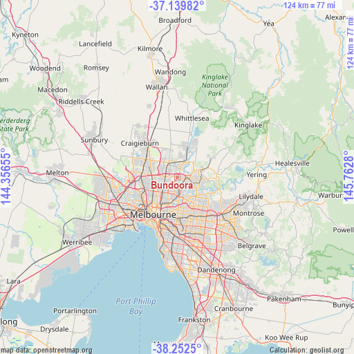
| Upper-left | -37.13982°, | 144.35655° |
| Center: | -37.69825°, | 145.05967° |
| Lower-right: | -38.2525°, | 145.7628° |
| Map W x H: | 123.7×123.7 km | = 76.9×76.9mi |
| max Lat: | -10.58257° ⇑84.7% North |
| Bundoora: | -37.69825° |
| min Lat: | ⇓15.3% South -43.31423° |
| min Long | Bundoora | max Long |
| 113.53327° | 145.05967° | 153.61246° |
| W 34.9%⇐ | ⇒65.1% E |
Elevation
Elevation of Bundoora is 101 m = 331 ft, and this is 21 m = 69 ft below average elevation for this country.
| Max E: |
1715 m = 5627 ft | 30.3% |
| Avg. | 122 m = 400 ft | |
| Bundoora | 101 m = 331 ft | |
Min E: |
-2 m = -7 ft | 69.7% |
See also: Australia elevation on elevation.city.
Geographical zone
Bundoora is located in South temperate zone (between Tropic of Capricorn and the Antarctic Circle). Distance of this Southern Tropic circle is 1585.7 km =985.3 mi to North.| Distance of | km | miles | from Bundoora |
|---|---|---|---|
| Equator | 4191.7 | 2604.6 | to North |
| Tropic Capricorn | 1585.7 | 985.3 | to North |
| Antarctic Circle | 3209.5 | 1994.3 | to South |
| South Pole | 5815.4 | 3613.5 | to South |


Nearby cities:
15 places around Bundoora: (largest is in red/bold)
• Briar Hill
5.5 km =3.4 mi,  99°
99°
• Greensborough
3.9 km =2.4 mi, 100°
• Heidelberg Heights
5 km =3.1 mi,  182°
182°
• Heidelberg West
4.9 km =3 mi,  200°
200°
• Kingsbury
2.8 km =1.7 mi,  230°
230°
• Lalor
5.2 km =3.2 mi,  312°
312°
• Macleod
3.9 km =2.4 mi,  171°
171°
• Mill Park
3.6 km =2.2 mi,  9°
9°
• Montmorency
5.4 km =3.4 mi,  112°
112°
• Rosanna
4.6 km =2.9 mi, 171°
• Thomastown
4.1 km =2.5 mi,  293°
293°
• Viewbank
5.5 km =3.4 mi,  147°
147°
• Watsonia
2.9 km =1.8 mi,  134°
134°
• Watsonia North
2.2 km =1.4 mi,  94°
94°
• Yallambie
4.2 km =2.6 mi,  135°
135°
Sources, notices
• [Note1] Compared only with cities in Australia existing in our database
• [Src1] Map data: © OpenStreetMap contributors (CC-BY-SA)
• [Src2] Other city data from geonames.org with taken over terms of usage.
• [Src3] Geographical zone / Annual Mean Temperature by Robert A. Rohde @ Wikipedia
