Kilkenny geodata
Kilkenny (South Australia) is a section of populated place; located in Australia in Australia/Adelaide (GMT+10.5) time zone. With population of 1,630 people, there are 3159 cities with bigger population in this country. Compared to other cities in Australia, 67.5% of cities are located further ↑North; 83% of cities are located further →East and 83.5% of cities have higher elevation than Kilkenny. Note1


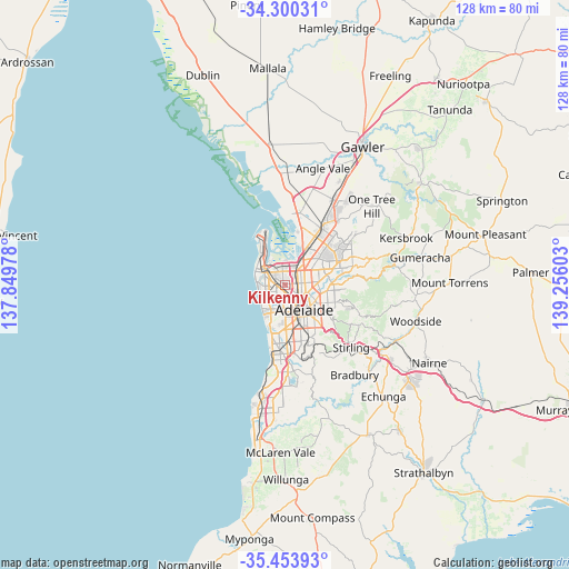
Kilkenny GPS coordinates[2]
34° 52' 44.904" South, 138° 33' 10.44" East
| Map corner | latitude | longitude |
|---|---|---|
| Upper-left | -34.30031°, | 137.84978° |
| Center: | -34.87914°, | 138.5529° |
| Lower-right: | -35.45393°, | 139.25603° |
| Map W x H: | 128.3×128.3 km | = 79.7×79.7mi |
| max Lat: | -10.58257° ⇑67.5% North |
| Kilkenny: | -34.87914° |
| min Lat: | ⇓32.5% South -43.31423° |
| min Long | Kilkenny | max Long |
| 113.53327° | 138.5529° | 153.61246° |
| W 17%⇐ | ⇒83% E |
Elevation
Elevation of Kilkenny is 13 m = 43 ft, and this is 109 m = 358 ft below average elevation for this country.
| Max E: |
1715 m = 5627 ft | 83.5% |
| Avg. | 122 m = 400 ft | |
| Kilkenny | 13 m = 43 ft | |
Min E: |
-2 m = -7 ft | 16.5% |
See also: Australia elevation on elevation.city.
Geographical zone
Kilkenny is located in South temperate zone (between Tropic of Capricorn and the Antarctic Circle). Distance of this Southern Tropic circle is 1272.3 km =790.6 mi to North.| Distance of | km | miles | from Kilkenny |
|---|---|---|---|
| Equator | 3878.2 | 2409.8 | to North |
| Tropic Capricorn | 1272.3 | 790.6 | to North |
| Antarctic Circle | 3523 | 2189.1 | to South |
| South Pole | 6128.9 | 3808.3 | to South |


Nearby cities:
15 places around Kilkenny: (largest is in red/bold)
• Allenby Gardens
2.1 km =1.3 mi,  176°
176°
• Angle Park
2.2 km =1.4 mi,  12°
12°
• Beverley
1.9 km =1.2 mi,  198°
198°
• Croydon Park
1.4 km =0.9 mi,  95°
95°
• Dudley Park
2.3 km =1.4 mi,  79°
79°
• Ferryden Park
1.7 km =1.1 mi,  29°
29°
• Mansfield Park
2.5 km =1.6 mi,  357°
357°
• Ridleyton
2.3 km =1.4 mi,  131°
131°
• West Croydon
1.8 km =1.1 mi,  161°
161°
• Woodville
0.9 km =0.6 mi,  284°
284°
• Woodville Gardens
1.3 km =0.8 mi,  340°
340°
• Woodville North
1.2 km =0.7 mi,  311°
311°
• Woodville Park
1 km =0.6 mi,  213°
213°
• Woodville South
1.7 km =1.1 mi,  259°
259°
• Woodville West
2.2 km =1.4 mi,  248°
248°
Sources, notices
• [Note1] Compared only with cities in Australia existing in our database
• [Src1] Map data: © OpenStreetMap contributors (CC-BY-SA)
• [Src2] Other city data from geonames.org with taken over terms of usage.
• [Src3] Geographical zone / Annual Mean Temperature by Robert A. Rohde @ Wikipedia
