Warabrook geodata
Warabrook (New South Wales) is a section of populated place; located in Australia in Australia/Sydney (GMT+11) time zone. With population of 1,923 people, there are 2957 cities with bigger population in this country. Compared to other cities in Australia, 59.2% of cities are located further ↓South; 80.7% of cities are located further ←West and 79% of cities have higher elevation than Warabrook. Note1


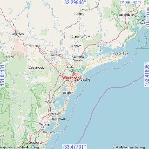
Warabrook GPS coordinates[2]
32° 53' 19.86" South, 151° 42' 53.748" East
| Map corner | latitude | longitude |
|---|---|---|
| Upper-left | -32.29646°, | 151.01181° |
| Center: | -32.88885°, | 151.71493° |
| Lower-right: | -33.47731°, | 152.41806° |
| Map W x H: | 131.3×131.3 km | = 81.6×81.6mi |
| max Lat: | -10.58257° ⇑40.8% North |
| Warabrook: | -32.88885° |
| min Lat: | ⇓59.2% South -43.31423° |
| min Long | Warabrook | max Long |
| 113.53327° | 151.71493° | 153.61246° |
| W 80.7%⇐ | ⇒19.3% E |
Elevation
Elevation of Warabrook is 16 m = 52 ft, and this is 106 m = 348 ft below average elevation for this country.
| Max E: |
1715 m = 5627 ft | 79% |
| Avg. | 122 m = 400 ft | |
| Warabrook | 16 m = 52 ft | |
Min E: |
-2 m = -7 ft | 21% |
See also: Australia elevation on elevation.city.
Geographical zone
Warabrook is located in South temperate zone (between Tropic of Capricorn and the Antarctic Circle). Distance of this Southern Tropic circle is 1051 km =653.1 mi to North.| Distance of | km | miles | from Warabrook |
|---|---|---|---|
| Equator | 3656.9 | 2272.3 | to North |
| Tropic Capricorn | 1051 | 653.1 | to North |
| Antarctic Circle | 3744.3 | 2326.6 | to South |
| South Pole | 6350.2 | 3945.8 | to South |


Nearby cities:
15 places around Warabrook: (largest is in red/bold)
• Birmingham Gardens
2.4 km =1.5 mi,  256°
256°
• Callaghan
1 km =0.6 mi,  248°
248°
• Georgetown
2.6 km =1.6 mi,  144°
144°
• Hamilton North
3.3 km =2.1 mi, 141°
• Islington
4.1 km =2.5 mi,  132°
132°
• Jesmond
2.7 km =1.7 mi,  235°
235°
• Lambton
3.4 km =2.1 mi,  204°
204°
• Mayfield
2.2 km =1.4 mi,  117°
117°
• Mayfield East
3.5 km =2.2 mi,  111°
111°
• Mayfield West
1.2 km =0.7 mi, 106°
• North Lambton
2.1 km =1.3 mi, 204°
• Shortland
2.5 km =1.6 mi,  296°
296°
• Tighes Hill
3.9 km =2.4 mi, 121°
• Waratah
2.3 km =1.4 mi,  151°
151°
• Waratah West
1.3 km =0.8 mi,  193°
193°
Sources, notices
• [Note1] Compared only with cities in Australia existing in our database
• [Src1] Map data: © OpenStreetMap contributors (CC-BY-SA)
• [Src2] Other city data from geonames.org with taken over terms of usage.
• [Src3] Geographical zone / Annual Mean Temperature by Robert A. Rohde @ Wikipedia
