Callaghan geodata
Callaghan (New South Wales) is a section of populated place; located in Australia in Australia/Sydney (GMT+11) time zone. With population of 1,529 people, there are 3261 cities with bigger population in this country. Compared to other cities in Australia, 59.1% of cities are located further ↓South; 80.5% of cities are located further ←West and 61.8% of cities have higher elevation than Callaghan. Note1


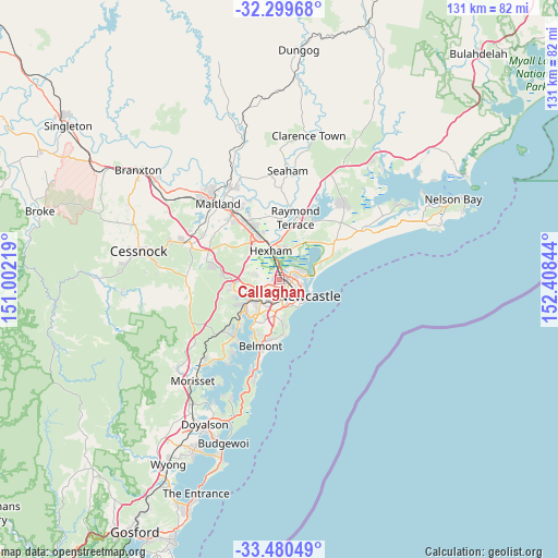
Callaghan GPS coordinates[2]
32° 53' 31.38" South, 151° 42' 19.116" East
| Map corner | latitude | longitude |
|---|---|---|
| Upper-left | -32.29968°, | 151.00219° |
| Center: | -32.89205°, | 151.70531° |
| Lower-right: | -33.48049°, | 152.40844° |
| Map W x H: | 131.3×131.3 km | = 81.6×81.6mi |
| max Lat: | -10.58257° ⇑40.9% North |
| Callaghan: | -32.89205° |
| min Lat: | ⇓59.1% South -43.31423° |
| min Long | Callaghan | max Long |
| 113.53327° | 151.70531° | 153.61246° |
| W 80.5%⇐ | ⇒19.5% E |
Elevation
Elevation of Callaghan is 30 m = 98 ft, and this is 92 m = 302 ft below average elevation for this country.
| Max E: |
1715 m = 5627 ft | 61.8% |
| Avg. | 122 m = 400 ft | |
| Callaghan | 30 m = 98 ft | |
Min E: |
-2 m = -7 ft | 38.2% |
See also: Australia elevation on elevation.city.
Geographical zone
Callaghan is located in South temperate zone (between Tropic of Capricorn and the Antarctic Circle). Distance of this Southern Tropic circle is 1051.3 km =653.2 mi to North.| Distance of | km | miles | from Callaghan |
|---|---|---|---|
| Equator | 3657.3 | 2272.5 | to North |
| Tropic Capricorn | 1051.3 | 653.2 | to North |
| Antarctic Circle | 3743.9 | 2326.4 | to South |
| South Pole | 6349.8 | 3945.6 | to South |


Nearby cities:
15 places around Callaghan: (largest is in red/bold)
• Birmingham Gardens
1.4 km =0.9 mi,  262°
262°
• Elermore Vale
3.8 km =2.4 mi,  224°
224°
• Georgetown
3 km =1.9 mi,  126°
126°
• Hamilton North
3.7 km =2.3 mi, 126°
• Jesmond
1.8 km =1.1 mi,  228°
228°
• Lambton
2.8 km =1.7 mi,  190°
190°
• Mayfield
3 km =1.9 mi,  102°
102°
• Mayfield West
2 km =1.2 mi,  89°
89°
• New Lambton Heights
3.8 km =2.4 mi,  196°
196°
• North Lambton
1.6 km =1 mi,  178°
178°
• Shortland
2 km =1.2 mi,  317°
317°
• Wallsend
4 km =2.5 mi,  254°
254°
• Warabrook
1 km =0.6 mi,  68°
68°
• Waratah
2.6 km =1.6 mi, 129°
• Waratah West
1.1 km =0.7 mi,  146°
146°
Sources, notices
• [Note1] Compared only with cities in Australia existing in our database
• [Src1] Map data: © OpenStreetMap contributors (CC-BY-SA)
• [Src2] Other city data from geonames.org with taken over terms of usage.
• [Src3] Geographical zone / Annual Mean Temperature by Robert A. Rohde @ Wikipedia
