Newmarket geodata
Newmarket (Queensland) is a section of populated place; located in Australia in Australia/Brisbane (GMT+10) time zone. With population of 4,817 people, there are 1529 cities with bigger population in this country. Compared to other cities in Australia, 83.2% of cities are located further ↓South; 91.4% of cities are located further ←West and 77.5% of cities have higher elevation than Newmarket. Note1


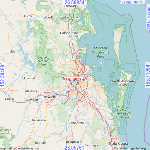
Newmarket GPS coordinates[2]
27° 26' 7.224" South, 153° 0' 28.116" East
| Map corner | latitude | longitude |
|---|---|---|
| Upper-left | -26.80954°, | 152.30469° |
| Center: | -27.43534°, | 153.00781° |
| Lower-right: | -28.05761°, | 153.71094° |
| Map W x H: | 138.8×138.8 km | = 86.2×86.2mi |
| max Lat: | -10.58257° ⇑16.8% North |
| Newmarket: | -27.43534° |
| min Lat: | ⇓83.2% South -43.31423° |
| min Long | Newmarket | max Long |
| 113.53327° | 153.00781° | 153.61246° |
| W 91.4%⇐ | ⇒8.6% E |
Elevation
Elevation of Newmarket is 17 m = 56 ft, and this is 105 m = 344 ft below average elevation for this country.
| Max E: |
1715 m = 5627 ft | 77.5% |
| Avg. | 122 m = 400 ft | |
| Newmarket | 17 m = 56 ft | |
Min E: |
-2 m = -7 ft | 22.5% |
See also: Australia elevation on elevation.city.
Geographical zone
Newmarket is located in South temperate zone (between Tropic of Capricorn and the Antarctic Circle). Distance of this Southern Tropic circle is 444.6 km =276.3 mi to North.| Distance of | km | miles | from Newmarket |
|---|---|---|---|
| Equator | 3050.5 | 1895.5 | to North |
| Tropic Capricorn | 444.6 | 276.3 | to North |
| Antarctic Circle | 4350.7 | 2703.4 | to South |
| South Pole | 6956.5 | 4322.6 | to South |


Nearby cities:
15 places around Newmarket: (largest is in red/bold)
• Alderley
1.3 km =0.8 mi,  328°
328°
• Ashgrove
1.9 km =1.2 mi,  234°
234°
• Bowen Hills
3.1 km =1.9 mi,  107°
107°
• Gaythorne
3.2 km =2 mi,  310°
310°
• Gordon Park
2.5 km =1.6 mi,  43°
43°
• Grange
1.6 km =1 mi,  27°
27°
• Herston
1.5 km =0.9 mi,  134°
134°
• Kelvin Grove
1.5 km =0.9 mi,  158°
158°
• Lutwyche
2.9 km =1.8 mi,  61°
61°
• Paddington
3 km =1.9 mi,  205°
205°
• Petrie Terrace
3.1 km =1.9 mi,  170°
170°
• Red Hill
2 km =1.2 mi,  196°
196°
• Stafford
2.8 km =1.7 mi,  6°
6°
• Wilston
1.2 km =0.7 mi,  72°
72°
• Windsor
2.1 km =1.3 mi,  92°
92°
Sources, notices
• [Note1] Compared only with cities in Australia existing in our database
• [Src1] Map data: © OpenStreetMap contributors (CC-BY-SA)
• [Src2] Other city data from geonames.org with taken over terms of usage.
• [Src3] Geographical zone / Annual Mean Temperature by Robert A. Rohde @ Wikipedia
