Alderley geodata
Alderley (Queensland) is a section of populated place; located in Australia in Australia/Brisbane (GMT+10) time zone. With population of 5,918 people, there are 1221 cities with bigger population in this country. Compared to other cities in Australia, 83.4% of cities are located further ↓South; 91.2% of cities are located further ←West and 55.2% of cities have higher elevation than Alderley. Note1


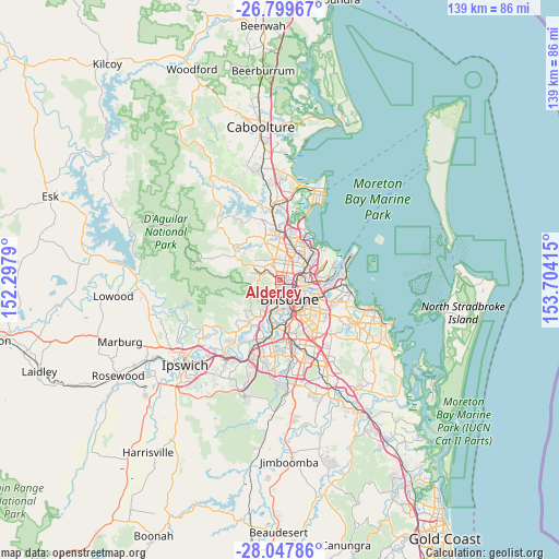
Alderley GPS coordinates[2]
27° 25' 31.908" South, 153° 0' 3.672" East
| Map corner | latitude | longitude |
|---|---|---|
| Upper-left | -26.79967°, | 152.2979° |
| Center: | -27.42553°, | 153.00102° |
| Lower-right: | -28.04786°, | 153.70415° |
| Map W x H: | 138.8×138.8 km | = 86.2×86.2mi |
| max Lat: | -10.58257° ⇑16.6% North |
| Alderley: | -27.42553° |
| min Lat: | ⇓83.4% South -43.31423° |
| min Long | Alderley | max Long |
| 113.53327° | 153.00102° | 153.61246° |
| W 91.2%⇐ | ⇒8.8% E |
Elevation
Elevation of Alderley is 38 m = 125 ft, and this is 84 m = 276 ft below average elevation for this country.
| Max E: |
1715 m = 5627 ft | 55.2% |
| Avg. | 122 m = 400 ft | |
| Alderley | 38 m = 125 ft | |
Min E: |
-2 m = -7 ft | 44.8% |
See also: Australia elevation on elevation.city.
Geographical zone
Alderley is located in South temperate zone (between Tropic of Capricorn and the Antarctic Circle). Distance of this Southern Tropic circle is 443.5 km =275.6 mi to North.| Distance of | km | miles | from Alderley |
|---|---|---|---|
| Equator | 3049.4 | 1894.8 | to North |
| Tropic Capricorn | 443.5 | 275.6 | to North |
| Antarctic Circle | 4351.7 | 2704 | to South |
| South Pole | 6957.6 | 4323.3 | to South |


Nearby cities:
15 places around Alderley: (largest is in red/bold)
• Ashgrove
2.4 km =1.5 mi,  201°
201°
• Enoggera
2.6 km =1.6 mi,  263°
263°
• Everton Park
2.4 km =1.5 mi,  328°
328°
• Gaythorne
2 km =1.2 mi,  299°
299°
• Gordon Park
2.5 km =1.6 mi,  73°
73°
• Grange
1.4 km =0.9 mi,  76°
76°
• Herston
2.7 km =1.7 mi,  140°
140°
• Kelvin Grove
2.8 km =1.7 mi,  154°
154°
• Lutwyche
3.2 km =2 mi, 84°
• Mitchelton
3.5 km =2.2 mi,  286°
286°
• Newmarket
1.3 km =0.8 mi, 148°
• Red Hill
3 km =1.9 mi,  178°
178°
• Stafford
1.9 km =1.2 mi,  30°
30°
• Wilston
1.9 km =1.2 mi,  112°
112°
• Windsor
3 km =1.9 mi, 113°
Sources, notices
• [Note1] Compared only with cities in Australia existing in our database
• [Src1] Map data: © OpenStreetMap contributors (CC-BY-SA)
• [Src2] Other city data from geonames.org with taken over terms of usage.
• [Src3] Geographical zone / Annual Mean Temperature by Robert A. Rohde @ Wikipedia
