Mansfield geodata
Mansfield (Queensland) is a section of populated place; located in Australia in Australia/Brisbane (GMT+10) time zone. With population of 8,588 people, there are 749 cities with bigger population in this country. Compared to other cities in Australia, 81.1% of cities are located further ↓South; 94.8% of cities are located further ←West and 53.7% of cities have higher elevation than Mansfield. Note1


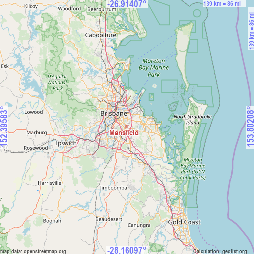
Mansfield GPS coordinates[2]
27° 32' 21.444" South, 153° 5' 56.22" East
| Map corner | latitude | longitude |
|---|---|---|
| Upper-left | -26.91407°, | 152.39583° |
| Center: | -27.53929°, | 153.09895° |
| Lower-right: | -28.16097°, | 153.80208° |
| Map W x H: | 138.6×138.6 km | = 86.1×86.1mi |
| max Lat: | -10.58257° ⇑18.9% North |
| Mansfield: | -27.53929° |
| min Lat: | ⇓81.1% South -43.31423° |
| min Long | Mansfield | max Long |
| 113.53327° | 153.09895° | 153.61246° |
| W 94.8%⇐ | ⇒5.2% E |
Elevation
Elevation of Mansfield is 40 m = 131 ft, and this is 82 m = 269 ft below average elevation for this country.
| Max E: |
1715 m = 5627 ft | 53.7% |
| Avg. | 122 m = 400 ft | |
| Mansfield | 40 m = 131 ft | |
Min E: |
-2 m = -7 ft | 46.3% |
See also: Australia elevation on elevation.city.
Geographical zone
Mansfield is located in South temperate zone (between Tropic of Capricorn and the Antarctic Circle). Distance of this Southern Tropic circle is 456.2 km =283.5 mi to North.| Distance of | km | miles | from Mansfield |
|---|---|---|---|
| Equator | 3062.1 | 1902.7 | to North |
| Tropic Capricorn | 456.2 | 283.5 | to North |
| Antarctic Circle | 4339.1 | 2696.2 | to South |
| South Pole | 6945 | 4315.4 | to South |


Nearby cities:
15 places around Mansfield: (largest is in red/bold)
• Burbank
5.1 km =3.2 mi,  111°
111°
• Carina Heights
3.6 km =2.2 mi,  347°
347°
• Carindale
3.7 km =2.3 mi,  5°
5°
• Eight Mile Plains
4.9 km =3 mi,  178°
178°
• Holland Park
4 km =2.5 mi,  308°
308°
• Holland Park West
4.1 km =2.5 mi,  290°
290°
• Macgregor
4.3 km =2.7 mi,  228°
228°
• Mackenzie
2.2 km =1.4 mi,  102°
102°
• Mount Gravatt
1.7 km =1.1 mi, 293°
• Mount Gravatt East
1.7 km =1.1 mi,  265°
265°
• Nathan
4.2 km =2.6 mi,  238°
238°
• Robertson
5 km =3.1 mi, 234°
• Rochedale
4.6 km =2.9 mi,  131°
131°
• Upper Mount Gravatt
2.8 km =1.7 mi,  210°
210°
• Wishart
1.7 km =1.1 mi,  172°
172°
Sources, notices
• [Note1] Compared only with cities in Australia existing in our database
• [Src1] Map data: © OpenStreetMap contributors (CC-BY-SA)
• [Src2] Other city data from geonames.org with taken over terms of usage.
• [Src3] Geographical zone / Annual Mean Temperature by Robert A. Rohde @ Wikipedia
