Mackenzie geodata
Mackenzie (Queensland) is a section of populated place; located in Australia in Australia/Brisbane (GMT+10) time zone. With population of 2,067 people, there are 2854 cities with bigger population in this country. Compared to other cities in Australia, 81% of cities are located further ↓South; 95.4% of cities are located further ←West and 50.4% of cities have higher elevation than Mackenzie. Note1


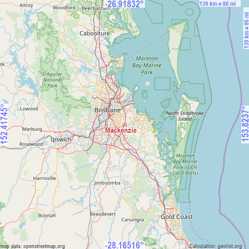
Mackenzie GPS coordinates[2]
27° 32' 36.636" South, 153° 7' 14.052" East
| Map corner | latitude | longitude |
|---|---|---|
| Upper-left | -26.91832°, | 152.41745° |
| Center: | -27.54351°, | 153.12057° |
| Lower-right: | -28.16516°, | 153.8237° |
| Map W x H: | 138.6×138.6 km | = 86.1×86.1mi |
| max Lat: | -10.58257° ⇑19% North |
| Mackenzie: | -27.54351° |
| min Lat: | ⇓81% South -43.31423° |
| min Long | Mackenzie | max Long |
| 113.53327° | 153.12057° | 153.61246° |
| W 95.4%⇐ | ⇒4.6% E |
Elevation
Elevation of Mackenzie is 45 m = 148 ft, and this is 77 m = 253 ft below average elevation for this country.
| Max E: |
1715 m = 5627 ft | 50.4% |
| Avg. | 122 m = 400 ft | |
| Mackenzie | 45 m = 148 ft | |
Min E: |
-2 m = -7 ft | 49.6% |
See also: Australia elevation on elevation.city.
Geographical zone
Mackenzie is located in South temperate zone (between Tropic of Capricorn and the Antarctic Circle). Distance of this Southern Tropic circle is 456.6 km =283.7 mi to North.| Distance of | km | miles | from Mackenzie |
|---|---|---|---|
| Equator | 3062.6 | 1903 | to North |
| Tropic Capricorn | 456.6 | 283.7 | to North |
| Antarctic Circle | 4338.6 | 2695.9 | to South |
| South Pole | 6944.5 | 4315.1 | to South |


Nearby cities:
15 places around Mackenzie: (largest is in red/bold)
• Belmont
5.1 km =3.2 mi,  14°
14°
• Burbank
2.9 km =1.8 mi,  117°
117°
• Carina Heights
5 km =3.1 mi,  324°
324°
• Carindale
4.6 km =2.9 mi,  336°
336°
• Chandler
4.3 km =2.7 mi,  40°
40°
• Eight Mile Plains
4.9 km =3 mi,  204°
204°
• Macgregor
5.8 km =3.6 mi,  245°
245°
• Mansfield
2.2 km =1.4 mi,  282°
282°
• Mount Gravatt
3.8 km =2.4 mi,  287°
287°
• Mount Gravatt East
3.8 km =2.4 mi, 275°
• Nathan
6 km =3.7 mi, 253°
• Rochedale
2.9 km =1.8 mi,  153°
153°
• Rochedale South
5.8 km =3.6 mi,  177°
177°
• Upper Mount Gravatt
4.1 km =2.5 mi,  240°
240°
• Wishart
2.3 km =1.4 mi, 237°
Sources, notices
• [Note1] Compared only with cities in Australia existing in our database
• [Src1] Map data: © OpenStreetMap contributors (CC-BY-SA)
• [Src2] Other city data from geonames.org with taken over terms of usage.
• [Src3] Geographical zone / Annual Mean Temperature by Robert A. Rohde @ Wikipedia
