Riverhills geodata
Riverhills (Queensland) is a section of populated place; located in Australia in Australia/Brisbane (GMT+10) time zone. With population of 3,982 people, there are 1796 cities with bigger population in this country. Compared to other cities in Australia, 80.5% of cities are located further ↓South; 88.8% of cities are located further ←West and 77.5% of cities have higher elevation than Riverhills. Note1


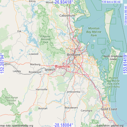
Riverhills GPS coordinates[2]
27° 33' 33.408" South, 152° 54' 39.816" East
| Map corner | latitude | longitude |
|---|---|---|
| Upper-left | -26.93418°, | 152.20794° |
| Center: | -27.55928°, | 152.91106° |
| Lower-right: | -28.18084°, | 153.61419° |
| Map W x H: | 138.6×138.6 km | = 86.1×86.1mi |
| max Lat: | -10.58257° ⇑19.5% North |
| Riverhills: | -27.55928° |
| min Lat: | ⇓80.5% South -43.31423° |
| min Long | Riverhills | max Long |
| 113.53327° | 152.91106° | 153.61246° |
| W 88.8%⇐ | ⇒11.2% E |
Elevation
Elevation of Riverhills is 17 m = 56 ft, and this is 105 m = 344 ft below average elevation for this country.
| Max E: |
1715 m = 5627 ft | 77.5% |
| Avg. | 122 m = 400 ft | |
| Riverhills | 17 m = 56 ft | |
Min E: |
-2 m = -7 ft | 22.5% |
See also: Australia elevation on elevation.city.
Geographical zone
Riverhills is located in South temperate zone (between Tropic of Capricorn and the Antarctic Circle). Distance of this Southern Tropic circle is 458.4 km =284.8 mi to North.| Distance of | km | miles | from Riverhills |
|---|---|---|---|
| Equator | 3064.3 | 1904.1 | to North |
| Tropic Capricorn | 458.4 | 284.8 | to North |
| Antarctic Circle | 4336.9 | 2694.8 | to South |
| South Pole | 6942.8 | 4314.1 | to South |


Nearby cities:
15 places around Riverhills: (largest is in red/bold)
• Anstead
5.4 km =3.4 mi,  296°
296°
• Bellbowrie
2.8 km =1.7 mi,  269°
269°
• Darra
4.3 km =2.7 mi,  101°
101°
• Jamboree Heights
2.3 km =1.4 mi,  81°
81°
• Jindalee
3.9 km =2.4 mi,  44°
44°
• Middle Park
1.2 km =0.7 mi,  71°
71°
• Moggill
5.1 km =3.2 mi,  238°
238°
• Mount Ommaney
2.5 km =1.6 mi,  54°
54°
• Pinjarra Hills
2.4 km =1.5 mi,  351°
351°
• Pullenvale
4.7 km =2.9 mi,  329°
329°
• Seventeen Mile Rocks
4.8 km =3 mi, 78°
• Sinnamon Park
4.1 km =2.5 mi, 66°
• Sumner
2.3 km =1.4 mi,  107°
107°
• Wacol
3.5 km =2.2 mi,  140°
140°
• Westlake
1.2 km =0.7 mi,  8°
8°
Sources, notices
• [Note1] Compared only with cities in Australia existing in our database
• [Src1] Map data: © OpenStreetMap contributors (CC-BY-SA)
• [Src2] Other city data from geonames.org with taken over terms of usage.
• [Src3] Geographical zone / Annual Mean Temperature by Robert A. Rohde @ Wikipedia
