Moggill geodata
Moggill (Queensland) is a section of populated place; located in Australia in Australia/Brisbane (GMT+10) time zone. With population of 4,582 people, there are 1604 cities with bigger population in this country. Compared to other cities in Australia, 79.9% of cities are located further ↓South; 88% of cities are located further ←West and 88.3% of cities have higher elevation than Moggill. Note1


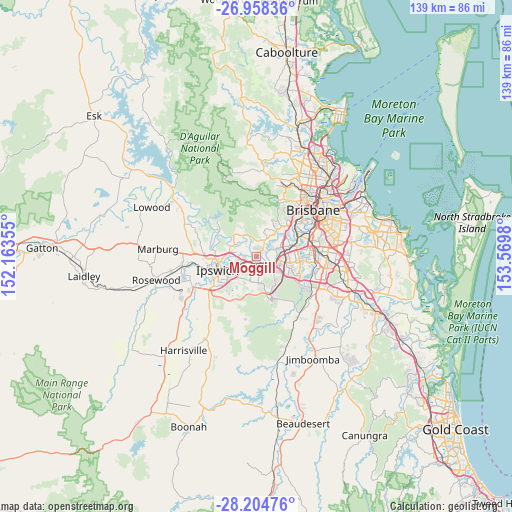
Moggill GPS coordinates[2]
27° 34' 59.988" South, 152° 52' 0.012" East
| Map corner | latitude | longitude |
|---|---|---|
| Upper-left | -26.95836°, | 152.16355° |
| Center: | -27.58333°, | 152.86667° |
| Lower-right: | -28.20476°, | 153.5698° |
| Map W x H: | 138.6×138.6 km | = 86.1×86.1mi |
| max Lat: | -10.58257° ⇑20.1% North |
| Moggill: | -27.58333° |
| min Lat: | ⇓79.9% South -43.31423° |
| min Long | Moggill | max Long |
| 113.53327° | 152.86667° | 153.61246° |
| W 88%⇐ | ⇒12% E |
Elevation
Elevation of Moggill is 10 m = 33 ft, and this is 112 m = 367 ft below average elevation for this country.
| Max E: |
1715 m = 5627 ft | 88.3% |
| Avg. | 122 m = 400 ft | |
| Moggill | 10 m = 33 ft | |
Min E: |
-2 m = -7 ft | 11.7% |
See also: Australia elevation on elevation.city.
Geographical zone
Moggill is located in South temperate zone (between Tropic of Capricorn and the Antarctic Circle). Distance of this Southern Tropic circle is 461.1 km =286.5 mi to North.| Distance of | km | miles | from Moggill |
|---|---|---|---|
| Equator | 3067 | 1905.7 | to North |
| Tropic Capricorn | 461.1 | 286.5 | to North |
| Antarctic Circle | 4334.2 | 2693.1 | to South |
| South Pole | 6940.1 | 4312.4 | to South |


Nearby cities:
15 places around Moggill: (largest is in red/bold)
• Anstead
5.1 km =3.2 mi,  354°
354°
• Barellan Point
2.6 km =1.6 mi,  299°
299°
• Bellbird Park
6.3 km =3.9 mi,  161°
161°
• Bellbowrie
3.1 km =1.9 mi,  30°
30°
• Bundamba
6.2 km =3.9 mi,  241°
241°
• Collingwood Park
3.3 km =2.1 mi,  191°
191°
• Dinmore
3.8 km =2.4 mi, 240°
• Gailes
5.5 km =3.4 mi,  124°
124°
• Goodna
4.4 km =2.7 mi,  133°
133°
• Karalee
4.6 km =2.9 mi, 296°
• Middle Park
6.3 km =3.9 mi,  60°
60°
• Redbank
1.9 km =1.2 mi,  180°
180°
• Riverhills
5.1 km =3.2 mi, 58°
• Riverview
2.5 km =1.6 mi,  221°
221°
• Westlake
6 km =3.7 mi,  49°
49°
Sources, notices
• [Note1] Compared only with cities in Australia existing in our database
• [Src1] Map data: © OpenStreetMap contributors (CC-BY-SA)
• [Src2] Other city data from geonames.org with taken over terms of usage.
• [Src3] Geographical zone / Annual Mean Temperature by Robert A. Rohde @ Wikipedia
