Bellbowrie geodata
Bellbowrie (Queensland) is a section of populated place; located in Australia in Australia/Brisbane (GMT+10) time zone. With population of 5,366 people, there are 1387 cities with bigger population in this country. Compared to other cities in Australia, 80.5% of cities are located further ↓South; 88.2% of cities are located further ←West and 53.1% of cities have higher elevation than Bellbowrie. Note1


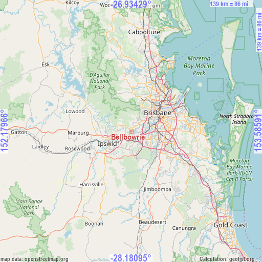
Bellbowrie GPS coordinates[2]
27° 33' 33.804" South, 152° 52' 58.008" East
| Map corner | latitude | longitude |
|---|---|---|
| Upper-left | -26.93429°, | 152.17966° |
| Center: | -27.55939°, | 152.88278° |
| Lower-right: | -28.18095°, | 153.58591° |
| Map W x H: | 138.6×138.6 km | = 86.1×86.1mi |
| max Lat: | -10.58257° ⇑19.5% North |
| Bellbowrie: | -27.55939° |
| min Lat: | ⇓80.5% South -43.31423° |
| min Long | Bellbowrie | max Long |
| 113.53327° | 152.88278° | 153.61246° |
| W 88.2%⇐ | ⇒11.8% E |
Elevation
Elevation of Bellbowrie is 41 m = 135 ft, and this is 81 m = 266 ft below average elevation for this country.
| Max E: |
1715 m = 5627 ft | 53.1% |
| Avg. | 122 m = 400 ft | |
| Bellbowrie | 41 m = 135 ft | |
Min E: |
-2 m = -7 ft | 46.9% |
See also: Australia elevation on elevation.city.
Geographical zone
Bellbowrie is located in South temperate zone (between Tropic of Capricorn and the Antarctic Circle). Distance of this Southern Tropic circle is 458.4 km =284.8 mi to North.| Distance of | km | miles | from Bellbowrie |
|---|---|---|---|
| Equator | 3064.3 | 1904.1 | to North |
| Tropic Capricorn | 458.4 | 284.8 | to North |
| Antarctic Circle | 4336.9 | 2694.8 | to South |
| South Pole | 6942.7 | 4314 | to South |


Nearby cities:
15 places around Bellbowrie: (largest is in red/bold)
• Anstead
3.2 km =2 mi,  319°
319°
• Barellan Point
4.1 km =2.5 mi,  250°
250°
• Jamboree Heights
5.1 km =3.2 mi,  86°
86°
• Karalee
5.8 km =3.6 mi,  263°
263°
• Middle Park
3.9 km =2.4 mi,  84°
84°
• Moggill
3.1 km =1.9 mi,  210°
210°
• Mount Ommaney
5.1 km =3.2 mi,  73°
73°
• Pinjarra Hills
3.4 km =2.1 mi,  46°
46°
• Pullenvale
4.1 km =2.5 mi,  5°
5°
• Redbank
4.8 km =3 mi,  199°
199°
• Riverhills
2.8 km =1.7 mi, 89°
• Riverview
5.6 km =3.5 mi,  215°
215°
• Sumner
5 km =3.1 mi,  97°
97°
• Wacol
5.6 km =3.5 mi,  118°
118°
• Westlake
3.2 km =2 mi, 67°
Sources, notices
• [Note1] Compared only with cities in Australia existing in our database
• [Src1] Map data: © OpenStreetMap contributors (CC-BY-SA)
• [Src2] Other city data from geonames.org with taken over terms of usage.
• [Src3] Geographical zone / Annual Mean Temperature by Robert A. Rohde @ Wikipedia
