Ravenhall geodata
Ravenhall (Victoria) is a section of populated place; located in Australia in Australia/Melbourne (GMT+11) time zone. With population of 1,155 people, there are 3634 cities with bigger population in this country. Compared to other cities in Australia, 86.4% of cities are located further ↑North; 69.3% of cities are located further →East and 61.7% of cities have lower elevation than Ravenhall. Note1


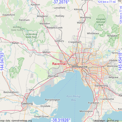
Ravenhall GPS coordinates[2]
37° 45' 55.872" South, 144° 45' 3.78" East
| Map corner | latitude | longitude |
|---|---|---|
| Upper-left | -37.2076°, | 144.04793° |
| Center: | -37.76552°, | 144.75105° |
| Lower-right: | -38.31926°, | 145.45418° |
| Map W x H: | 123.6×123.6 km | = 76.8×76.8mi |
| max Lat: | -10.58257° ⇑86.4% North |
| Ravenhall: | -37.76552° |
| min Lat: | ⇓13.6% South -43.31423° |
| min Long | Ravenhall | max Long |
| 113.53327° | 144.75105° | 153.61246° |
| W 30.7%⇐ | ⇒69.3% E |
Elevation
Elevation of Ravenhall is 69 m = 226 ft, and this is 53 m = 174 ft below average elevation for this country.
| Max E: |
1715 m = 5627 ft | 38.3% |
| Avg. | 122 m = 400 ft | |
| Ravenhall | 69 m = 226 ft | |
Min E: |
-2 m = -7 ft | 61.7% |
See also: Australia elevation on elevation.city.
Geographical zone
Ravenhall is located in South temperate zone (between Tropic of Capricorn and the Antarctic Circle). Distance of this Southern Tropic circle is 1593.2 km =990 mi to North.| Distance of | km | miles | from Ravenhall |
|---|---|---|---|
| Equator | 4199.1 | 2609.2 | to North |
| Tropic Capricorn | 1593.2 | 990 | to North |
| Antarctic Circle | 3202 | 1989.6 | to South |
| South Pole | 5807.9 | 3608.9 | to South |


Nearby cities:
15 places around Ravenhall: (largest is in red/bold)
• Albanvale
2.7 km =1.7 mi,  35°
35°
• Albion
6 km =3.7 mi,  105°
105°
• Ardeer
4.6 km =2.9 mi,  104°
104°
• Burnside
1.8 km =1.1 mi,  5°
5°
• Burnside Heights
4.3 km =2.7 mi,  1°
1°
• Cairnlea
3.3 km =2.1 mi,  77°
77°
• Caroline Springs
3 km =1.9 mi,  334°
334°
• Deer Park
1.4 km =0.9 mi, 97°
• Delahey
5.6 km =3.5 mi,  24°
24°
• Derrimut
3.4 km =2.1 mi,  150°
150°
• Kings Park
4.2 km =2.6 mi,  33°
33°
• Saint Albans
5.6 km =3.5 mi,  50°
50°
• St Albans
4.9 km =3 mi,  62°
62°
• Taylors Hill
6.2 km =3.9 mi, 3°
• Truganina
5.7 km =3.5 mi,  180°
180°
Sources, notices
• [Note1] Compared only with cities in Australia existing in our database
• [Src1] Map data: © OpenStreetMap contributors (CC-BY-SA)
• [Src2] Other city data from geonames.org with taken over terms of usage.
• [Src3] Geographical zone / Annual Mean Temperature by Robert A. Rohde @ Wikipedia
