Balmain geodata
Balmain (New South Wales) is a section of populated place; located in Australia in Australia/Sydney (GMT+10) time zone. With population of 10,305 people, there are 558 cities with bigger population in this country. Compared to other cities in Australia, 53.9% of cities are located further ↑North; 72.6% of cities are located further ←West and 83.5% of cities have higher elevation than Balmain. Note1


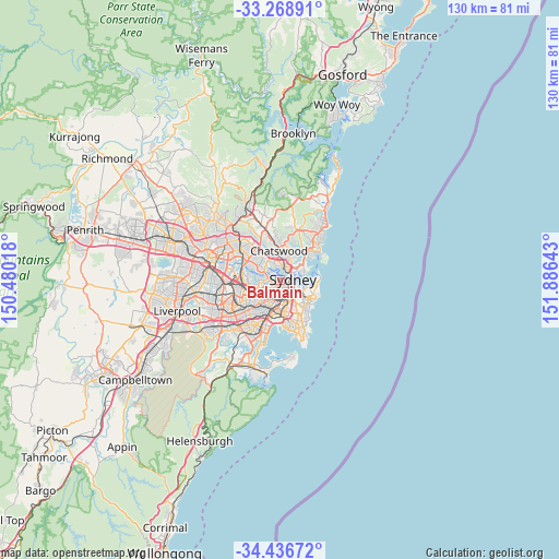
Balmain GPS coordinates[2]
33° 51' 17.316" South, 151° 10' 59.88" East
| Map corner | latitude | longitude |
|---|---|---|
| Upper-left | -33.26891°, | 150.48018° |
| Center: | -33.85481°, | 151.1833° |
| Lower-right: | -34.43672°, | 151.88643° |
| Map W x H: | 129.8×129.8 km | = 80.7×80.7mi |
| max Lat: | -10.58257° ⇑53.9% North |
| Balmain: | -33.85481° |
| min Lat: | ⇓46.1% South -43.31423° |
| min Long | Balmain | max Long |
| 113.53327° | 151.1833° | 153.61246° |
| W 72.6%⇐ | ⇒27.4% E |
Elevation
Elevation of Balmain is 13 m = 43 ft, and this is 109 m = 358 ft below average elevation for this country.
| Max E: |
1715 m = 5627 ft | 83.5% |
| Avg. | 122 m = 400 ft | |
| Balmain | 13 m = 43 ft | |
Min E: |
-2 m = -7 ft | 16.5% |
See also: Australia elevation on elevation.city.
Geographical zone
Balmain is located in South temperate zone (between Tropic of Capricorn and the Antarctic Circle). Distance of this Southern Tropic circle is 1158.4 km =719.8 mi to North.| Distance of | km | miles | from Balmain |
|---|---|---|---|
| Equator | 3764.3 | 2339 | to North |
| Tropic Capricorn | 1158.4 | 719.8 | to North |
| Antarctic Circle | 3636.9 | 2259.9 | to South |
| South Pole | 6242.8 | 3879.1 | to South |


Nearby cities:
15 places around Balmain: (largest is in red/bold)
• Balmain East
0.9 km =0.6 mi,  106°
106°
• Birchgrove
0.4 km =0.2 mi,  347°
347°
• Drummoyne
2.6 km =1.6 mi,  275°
275°
• Greenwich
1.7 km =1.1 mi,  359°
359°
• Lavender Bay
2.6 km =1.6 mi,  61°
61°
• McMahons Point
2.1 km =1.3 mi, 58°
• Millers Point
2 km =1.2 mi, 105°
• Pyrmont
1.9 km =1.2 mi,  149°
149°
• Rozelle
1.4 km =0.9 mi,  238°
238°
• Sydney
2.6 km =1.6 mi,  123°
123°
• Sydney Central Business District
2.5 km =1.6 mi, 116°
• The Rocks
2.3 km =1.4 mi,  102°
102°
• Waverton
2.4 km =1.5 mi,  41°
41°
• Wollstonecraft
2.5 km =1.6 mi,  13°
13°
• Woolwich
2.1 km =1.3 mi,  321°
321°
Sources, notices
• [Note1] Compared only with cities in Australia existing in our database
• [Src1] Map data: © OpenStreetMap contributors (CC-BY-SA)
• [Src2] Other city data from geonames.org with taken over terms of usage.
• [Src3] Geographical zone / Annual Mean Temperature by Robert A. Rohde @ Wikipedia
