Port Noarlunga South geodata
Port Noarlunga South (South Australia) is a section of populated place; located in Australia in Australia/Adelaide (GMT+10.5) time zone. With population of 2,668 people, there are 2453 cities with bigger population in this country. Compared to other cities in Australia, 74% of cities are located further ↑North; 85% of cities are located further →East and 68.6% of cities have higher elevation than Port Noarlunga South. Note1


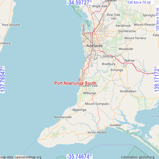
Port Noarlunga South GPS coordinates[2]
35° 10' 26.544" South, 138° 28' 6.924" East
| Map corner | latitude | longitude |
|---|---|---|
| Upper-left | -34.59727°, | 137.76547° |
| Center: | -35.17404°, | 138.46859° |
| Lower-right: | -35.74674°, | 139.17172° |
| Map W x H: | 127.8×127.8 km | = 79.4×79.4mi |
| max Lat: | -10.58257° ⇑74% North |
| Port Noarlunga South: | -35.17404° |
| min Lat: | ⇓26% South -43.31423° |
| min Long | Port Noarlunga | max Long |
| 113.53327° | 138.46859° | 153.61246° |
| W 15%⇐ | ⇒85% E |
Elevation
Elevation of Port Noarlunga South is 24 m = 79 ft, and this is 98 m = 322 ft below average elevation for this country.
| Max E: |
1715 m = 5627 ft | 68.6% |
| Avg. | 122 m = 400 ft | |
| Port Noarlunga South | 24 m = 79 ft | |
Min E: |
-2 m = -7 ft | 31.4% |
See also: Australia elevation on elevation.city.
Geographical zone
Port Noarlunga South is located in South temperate zone (between Tropic of Capricorn and the Antarctic Circle). Distance of this Southern Tropic circle is 1305.1 km =811 mi to North.| Distance of | km | miles | from Port Noarlunga South |
|---|---|---|---|
| Equator | 3911 | 2430.2 | to North |
| Tropic Capricorn | 1305.1 | 811 | to North |
| Antarctic Circle | 3490.2 | 2168.7 | to South |
| South Pole | 6096.1 | 3787.9 | to South |


Nearby cities:
15 places around Port Noarlunga South: (largest is in red/bold)
• Christie Downs
5.5 km =3.4 mi,  27°
27°
• Christies Beach
3.9 km =2.4 mi,  4°
4°
• Hackham
5.5 km =3.4 mi,  67°
67°
• Hackham West
5.4 km =3.4 mi,  50°
50°
• Huntfield Heights
4.7 km =2.9 mi,  62°
62°
• Maslin Beach
5.9 km =3.7 mi,  169°
169°
• Moana
2.3 km =1.4 mi,  162°
162°
• Morphett Vale
6.3 km =3.9 mi,  43°
43°
• Noarlunga Downs
4.2 km =2.6 mi, 50°
• O'Sullivan Beach
6.2 km =3.9 mi, 4°
• Old Noarlunga
3.1 km =1.9 mi,  106°
106°
• Port Noarlunga
2.9 km =1.8 mi, 4°
• Seaford
1.9 km =1.2 mi, 159°
• Seaford Meadows
1.8 km =1.1 mi,  85°
85°
• Seaford Rise
2.4 km =1.5 mi,  150°
150°
Sources, notices
• [Note1] Compared only with cities in Australia existing in our database
• [Src1] Map data: © OpenStreetMap contributors (CC-BY-SA)
• [Src2] Other city data from geonames.org with taken over terms of usage.
• [Src3] Geographical zone / Annual Mean Temperature by Robert A. Rohde @ Wikipedia
