Floraville geodata
Floraville (New South Wales) is a section of populated place; located in Australia in Australia/Sydney (GMT+11) time zone. With population of 1,836 people, there are 3016 cities with bigger population in this country. Compared to other cities in Australia, 57.4% of cities are located further ↓South; 80% of cities are located further ←West and 57.4% of cities have lower elevation than Floraville. Note1


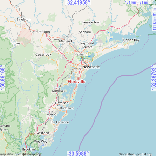
Floraville GPS coordinates[2]
33° 0' 40.176" South, 151° 39' 53.28" East
| Map corner | latitude | longitude |
|---|---|---|
| Upper-left | -32.41958°, | 150.96168° |
| Center: | -33.01116°, | 151.6648° |
| Lower-right: | -33.5988°, | 152.36793° |
| Map W x H: | 131.1×131.1 km | = 81.5×81.5mi |
| max Lat: | -10.58257° ⇑42.6% North |
| Floraville: | -33.01116° |
| min Lat: | ⇓57.4% South -43.31423° |
| min Long | Floraville | max Long |
| 113.53327° | 151.6648° | 153.61246° |
| W 80%⇐ | ⇒20% E |
Elevation
Elevation of Floraville is 58 m = 190 ft, and this is 64 m = 210 ft below average elevation for this country.
| Max E: |
1715 m = 5627 ft | 42.6% |
| Avg. | 122 m = 400 ft | |
| Floraville | 58 m = 190 ft | |
Min E: |
-2 m = -7 ft | 57.4% |
See also: Australia elevation on elevation.city.
Geographical zone
Floraville is located in South temperate zone (between Tropic of Capricorn and the Antarctic Circle). Distance of this Southern Tropic circle is 1064.6 km =661.5 mi to North.| Distance of | km | miles | from Floraville |
|---|---|---|---|
| Equator | 3670.5 | 2280.7 | to North |
| Tropic Capricorn | 1064.6 | 661.5 | to North |
| Antarctic Circle | 3730.7 | 2318.1 | to South |
| South Pole | 6336.6 | 3937.4 | to South |


Nearby cities:
15 places around Floraville: (largest is in red/bold)
• Belmont
1.9 km =1.2 mi,  193°
193°
• Belmont North
1.1 km =0.7 mi,  162°
162°
• Belmont South
4.3 km =2.7 mi, 189°
• Croudace Bay
1.7 km =1.1 mi,  294°
294°
• Eleebana
3.6 km =2.2 mi,  312°
312°
• Gateshead
4.1 km =2.5 mi,  37°
37°
• Hillsborough
5.1 km =3.2 mi,  7°
7°
• Jewells
1.7 km =1.1 mi,  99°
99°
• Marks Point
5.2 km =3.2 mi,  195°
195°
• Mount Hutton
3.1 km =1.9 mi, 9°
• Redhead
4.3 km =2.7 mi,  90°
90°
• Tingira Heights
1.6 km =1 mi,  18°
18°
• Valentine
2.1 km =1.3 mi,  258°
258°
• Warners Bay
4.4 km =2.7 mi,  345°
345°
• Windale
2.6 km =1.6 mi, 37°
Sources, notices
• [Note1] Compared only with cities in Australia existing in our database
• [Src1] Map data: © OpenStreetMap contributors (CC-BY-SA)
• [Src2] Other city data from geonames.org with taken over terms of usage.
• [Src3] Geographical zone / Annual Mean Temperature by Robert A. Rohde @ Wikipedia
