Windale geodata
Windale (New South Wales) is a section of populated place; located in Australia in Australia/Sydney (GMT+11) time zone. With population of 3,351 people, there are 2047 cities with bigger population in this country. Compared to other cities in Australia, 57.6% of cities are located further ↓South; 80.3% of cities are located further ←West and 58.4% of cities have higher elevation than Windale. Note1


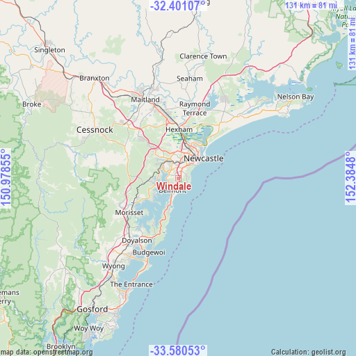
Windale GPS coordinates[2]
32° 59' 33.972" South, 151° 40' 54.012" East
| Map corner | latitude | longitude |
|---|---|---|
| Upper-left | -32.40107°, | 150.97855° |
| Center: | -32.99277°, | 151.68167° |
| Lower-right: | -33.58053°, | 152.3848° |
| Map W x H: | 131.1×131.1 km | = 81.5×81.5mi |
| max Lat: | -10.58257° ⇑42.4% North |
| Windale: | -32.99277° |
| min Lat: | ⇓57.6% South -43.31423° |
| min Long | Windale | max Long |
| 113.53327° | 151.68167° | 153.61246° |
| W 80.3%⇐ | ⇒19.7% E |
Elevation
Elevation of Windale is 34 m = 112 ft, and this is 88 m = 289 ft below average elevation for this country.
| Max E: |
1715 m = 5627 ft | 58.4% |
| Avg. | 122 m = 400 ft | |
| Windale | 34 m = 112 ft | |
Min E: |
-2 m = -7 ft | 41.6% |
See also: Australia elevation on elevation.city.
Geographical zone
Windale is located in South temperate zone (between Tropic of Capricorn and the Antarctic Circle). Distance of this Southern Tropic circle is 1062.5 km =660.2 mi to North.| Distance of | km | miles | from Windale |
|---|---|---|---|
| Equator | 3668.5 | 2279.5 | to North |
| Tropic Capricorn | 1062.5 | 660.2 | to North |
| Antarctic Circle | 3732.7 | 2319.4 | to South |
| South Pole | 6338.6 | 3938.6 | to South |


Nearby cities:
15 places around Windale: (largest is in red/bold)
• Belmont
4.3 km =2.7 mi,  207°
207°
• Belmont North
3.4 km =2.1 mi,  201°
201°
• Charlestown
2.9 km =1.8 mi,  21°
21°
• Croudace Bay
3.4 km =2.1 mi,  246°
246°
• Dudley
3.8 km =2.4 mi,  91°
91°
• Eleebana
4.2 km =2.6 mi,  274°
274°
• Floraville
2.6 km =1.6 mi,  217°
217°
• Gateshead
1.5 km =0.9 mi,  38°
38°
• Hillsborough
3.2 km =2 mi,  343°
343°
• Jewells
2.3 km =1.4 mi,  176°
176°
• Mount Hutton
1.5 km =0.9 mi,  314°
314°
• Redhead
3.5 km =2.2 mi,  127°
127°
• Tingira Heights
1.2 km =0.7 mi, 245°
• Warners Bay
3.5 km =2.2 mi, 309°
• Whitebridge
3.8 km =2.4 mi,  57°
57°
Sources, notices
• [Note1] Compared only with cities in Australia existing in our database
• [Src1] Map data: © OpenStreetMap contributors (CC-BY-SA)
• [Src2] Other city data from geonames.org with taken over terms of usage.
• [Src3] Geographical zone / Annual Mean Temperature by Robert A. Rohde @ Wikipedia
