Gateshead geodata
Gateshead (New South Wales) is a section of populated place; located in Australia in Australia/Sydney (GMT+11) time zone. With population of 3,231 people, there are 2107 cities with bigger population in this country. Compared to other cities in Australia, 57.7% of cities are located further ↓South; 80.4% of cities are located further ←West and 55.9% of cities have higher elevation than Gateshead. Note1


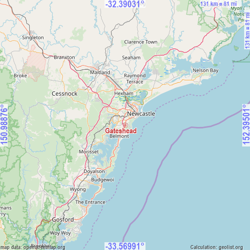
Gateshead GPS coordinates[2]
32° 58' 55.488" South, 151° 41' 30.768" East
| Map corner | latitude | longitude |
|---|---|---|
| Upper-left | -32.39031°, | 150.98876° |
| Center: | -32.98208°, | 151.69188° |
| Lower-right: | -33.56991°, | 152.39501° |
| Map W x H: | 131.2×131.2 km | = 81.5×81.5mi |
| max Lat: | -10.58257° ⇑42.3% North |
| Gateshead: | -32.98208° |
| min Lat: | ⇓57.7% South -43.31423° |
| min Long | Gateshead | max Long |
| 113.53327° | 151.69188° | 153.61246° |
| W 80.4%⇐ | ⇒19.6% E |
Elevation
Elevation of Gateshead is 37 m = 121 ft, and this is 85 m = 279 ft below average elevation for this country.
| Max E: |
1715 m = 5627 ft | 55.9% |
| Avg. | 122 m = 400 ft | |
| Gateshead | 37 m = 121 ft | |
Min E: |
-2 m = -7 ft | 44.1% |
See also: Australia elevation on elevation.city.
Geographical zone
Gateshead is located in South temperate zone (between Tropic of Capricorn and the Antarctic Circle). Distance of this Southern Tropic circle is 1061.3 km =659.5 mi to North.| Distance of | km | miles | from Gateshead |
|---|---|---|---|
| Equator | 3667.3 | 2278.8 | to North |
| Tropic Capricorn | 1061.3 | 659.5 | to North |
| Antarctic Circle | 3733.9 | 2320.1 | to South |
| South Pole | 6339.8 | 3939.4 | to South |


Nearby cities:
15 places around Gateshead: (largest is in red/bold)
• Adamstown Heights
4 km =2.5 mi,  24°
24°
• Cardiff South
4 km =2.5 mi,  319°
319°
• Charlestown
1.5 km =0.9 mi,  4°
4°
• Dudley
3.1 km =1.9 mi,  114°
114°
• Highfields
3.7 km =2.3 mi,  30°
30°
• Hillsborough
2.6 km =1.6 mi, 315°
• Jewells
3.6 km =2.2 mi,  193°
193°
• Kahibah
3 km =1.9 mi,  40°
40°
• Kotara South
3.3 km =2.1 mi,  358°
358°
• Mount Hutton
2 km =1.2 mi,  266°
266°
• Redhead
3.8 km =2.4 mi,  151°
151°
• Tingira Heights
2.6 km =1.6 mi,  230°
230°
• Warners Bay
3.8 km =2.4 mi,  286°
286°
• Whitebridge
2.4 km =1.5 mi,  69°
69°
• Windale
1.5 km =0.9 mi,  218°
218°
Sources, notices
• [Note1] Compared only with cities in Australia existing in our database
• [Src1] Map data: © OpenStreetMap contributors (CC-BY-SA)
• [Src2] Other city data from geonames.org with taken over terms of usage.
• [Src3] Geographical zone / Annual Mean Temperature by Robert A. Rohde @ Wikipedia
