Wallsend geodata
Wallsend (New South Wales) is a section of populated place; located in Australia in Australia/Sydney (GMT+11) time zone. With population of 12,344 people, there are 391 cities with bigger population in this country. Compared to other cities in Australia, 59% of cities are located further ↓South; 79.9% of cities are located further ←West and 73.6% of cities have higher elevation than Wallsend. Note1


Wallsend GPS coordinates[2]
32° 54' 4.788" South, 151° 39' 51.552" East
| Map corner | latitude | longitude |
|---|---|---|
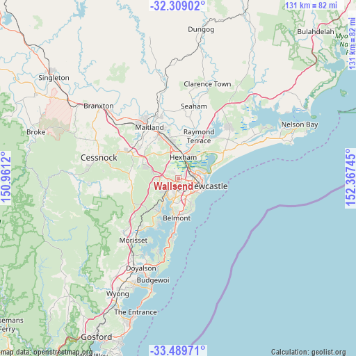
| Upper-left | -32.30902°, | 150.9612° |
| Center: | -32.90133°, | 151.66432° |
| Lower-right: | -33.48971°, | 152.36745° |
| Map W x H: | 131.3×131.3 km | = 81.6×81.6mi |
| max Lat: | -10.58257° ⇑41% North |
| Wallsend: | -32.90133° |
| min Lat: | ⇓59% South -43.31423° |
| min Long | Wallsend | max Long |
| 113.53327° | 151.66432° | 153.61246° |
| W 79.9%⇐ | ⇒20.1% E |
Elevation
Elevation of Wallsend is 20 m = 66 ft, and this is 102 m = 335 ft below average elevation for this country.
| Max E: |
1715 m = 5627 ft | 73.6% |
| Avg. | 122 m = 400 ft | |
| Wallsend | 20 m = 66 ft | |
Min E: |
-2 m = -7 ft | 26.4% |
See also: Australia elevation on elevation.city.
Geographical zone
Wallsend is located in South temperate zone (between Tropic of Capricorn and the Antarctic Circle). Distance of this Southern Tropic circle is 1052.4 km =653.9 mi to North.| Distance of | km | miles | from Wallsend |
|---|---|---|---|
| Equator | 3658.3 | 2273.2 | to North |
| Tropic Capricorn | 1052.4 | 653.9 | to North |
| Antarctic Circle | 3742.9 | 2325.7 | to South |
| South Pole | 6348.8 | 3945 | to South |


Nearby cities:
15 places around Wallsend: (largest is in red/bold)
• Birmingham Gardens
2.6 km =1.6 mi,  70°
70°
• Callaghan
4 km =2.5 mi, 74°
• Cardiff
4.6 km =2.9 mi,  191°
191°
• Cardiff Heights
4 km =2.5 mi,  169°
169°
• Elermore Vale
2 km =1.2 mi,  145°
145°
• Fletcher
3.9 km =2.4 mi,  324°
324°
• Glendale
4 km =2.5 mi,  212°
212°
• Jesmond
2.5 km =1.6 mi,  93°
93°
• Lambton
3.7 km =2.3 mi,  117°
117°
• Maryland
2.5 km =1.6 mi,  353°
353°
• New Lambton Heights
3.8 km =2.4 mi,  133°
133°
• North Lambton
3.9 km =2.4 mi,  97°
97°
• Rankin Park
3 km =1.9 mi, 150°
• Shortland
3.5 km =2.2 mi,  44°
44°
• Waratah West
4.4 km =2.7 mi, 88°
Sources, notices
• [Note1] Compared only with cities in Australia existing in our database
• [Src1] Map data: © OpenStreetMap contributors (CC-BY-SA)
• [Src2] Other city data from geonames.org with taken over terms of usage.
• [Src3] Geographical zone / Annual Mean Temperature by Robert A. Rohde @ Wikipedia
