Hodgson Vale geodata
Hodgson Vale (Queensland) is a section of populated place; located in Australia in Australia/Brisbane (GMT+10) time zone. With population of 1,345 people, there are 3424 cities with bigger population in this country. Compared to other cities in Australia, 78.1% of cities are located further ↓South; 82% of cities are located further ←West and 93.9% of cities have lower elevation than Hodgson Vale. Note1


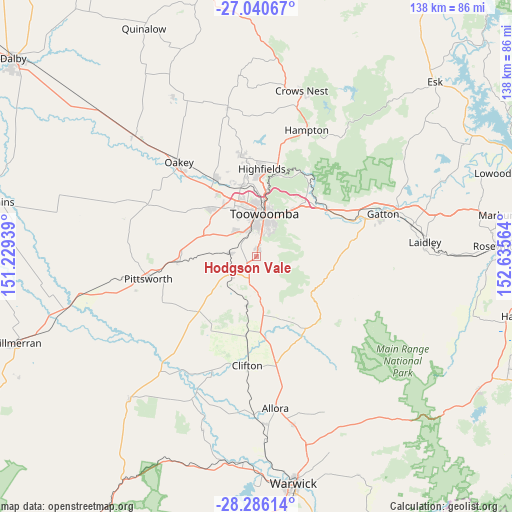
Hodgson Vale GPS coordinates[2]
27° 39' 54.648" South, 151° 55' 57.036" East
| Map corner | latitude | longitude |
|---|---|---|
| Upper-left | -27.04067°, | 151.22939° |
| Center: | -27.66518°, | 151.93251° |
| Lower-right: | -28.28614°, | 152.63564° |
| Map W x H: | 138.5×138.5 km | = 86.1×86.1mi |
| max Lat: | -10.58257° ⇑21.9% North |
| Hodgson Vale: | -27.66518° |
| min Lat: | ⇓78.1% South -43.31423° |
| min Long | Hodgson Vale | max Long |
| 113.53327° | 151.93251° | 153.61246° |
| W 82%⇐ | ⇒18% E |
Elevation
Elevation of Hodgson Vale is 531 m = 1742 ft, and this is 409 m = 1342 ft above average elevation for this country.
| Max E: |
1715 m = 5627 ft | 6.1% |
| Hodgson Vale | 531 m 1742 ft | |
| Avg. | 122 m = 400 ft | |
Min E: |
-2 m = -7 ft | 93.9% |
See also: Australia elevation on elevation.city.
Geographical zone
Hodgson Vale is located in South temperate zone (between Tropic of Capricorn and the Antarctic Circle). Distance of this Southern Tropic circle is 470.2 km =292.2 mi to North.| Distance of | km | miles | from Hodgson Vale |
|---|---|---|---|
| Equator | 3076.1 | 1911.4 | to North |
| Tropic Capricorn | 470.2 | 292.2 | to North |
| Antarctic Circle | 4325.1 | 2687.5 | to South |
| South Pole | 6931 | 4306.7 | to South |


Nearby cities:
15 places around Hodgson Vale: (largest is in red/bold)
• Cambooya
9 km =5.6 mi,  232°
232°
• Centenary Heights
9.2 km =5.7 mi,  18°
18°
• Darling Heights
7.6 km =4.7 mi,  358°
358°
• Drayton
7.9 km =4.9 mi,  336°
336°
• East Toowoomba
11.3 km =7 mi, 21°
• Glenvale
11.5 km =7.1 mi, 340°
• Harristown
9.1 km =5.7 mi,  0°
0°
• Kearneys Spring
6.7 km =4.2 mi,  7°
7°
• Middle Ridge
7.3 km =4.5 mi,  27°
27°
• Preston
5.4 km =3.4 mi,  84°
84°
• Rangeville
10.2 km =6.3 mi, 27°
• South Toowoomba
10.6 km =6.6 mi, 7°
• Top Camp
3.3 km =2.1 mi, 11°
• Westbrook
8.4 km =5.2 mi,  309°
309°
• Wyreema
7.7 km =4.8 mi,  277°
277°
Sources, notices
• [Note1] Compared only with cities in Australia existing in our database
• [Src1] Map data: © OpenStreetMap contributors (CC-BY-SA)
• [Src2] Other city data from geonames.org with taken over terms of usage.
• [Src3] Geographical zone / Annual Mean Temperature by Robert A. Rohde @ Wikipedia
