North Macksville geodata
North Macksville (New South Wales) is a section of populated place; located in Australia in Australia/Sydney (GMT+11) time zone. With population of 599 people, there are 4572 cities with bigger population in this country. Compared to other cities in Australia, 71.3% of cities are located further ↓South; 89.4% of cities are located further ←West and 74.7% of cities have higher elevation than North Macksville. Note1


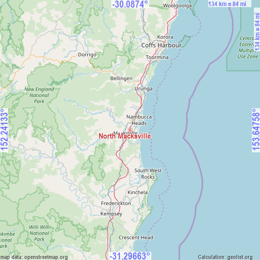
North Macksville GPS coordinates[2]
30° 41' 38.076" South, 152° 56' 40.02" East
| Map corner | latitude | longitude |
|---|---|---|
| Upper-left | -30.0874°, | 152.24133° |
| Center: | -30.69391°, | 152.94445° |
| Lower-right: | -31.29663°, | 153.64758° |
| Map W x H: | 134.5×134.5 km | = 83.6×83.6mi |
| max Lat: | -10.58257° ⇑28.7% North |
| North Macksville: | -30.69391° |
| min Lat: | ⇓71.3% South -43.31423° |
| min Long | North Macksvill | max Long |
| 113.53327° | 152.94445° | 153.61246° |
| W 89.4%⇐ | ⇒10.6% E |
Elevation
Elevation of North Macksville is 19 m = 62 ft, and this is 103 m = 338 ft below average elevation for this country.
| Max E: |
1715 m = 5627 ft | 74.7% |
| Avg. | 122 m = 400 ft | |
| North Macksville | 19 m = 62 ft | |
Min E: |
-2 m = -7 ft | 25.3% |
See also: Australia elevation on elevation.city.
Geographical zone
North Macksville is located in South temperate zone (between Tropic of Capricorn and the Antarctic Circle). Distance of this Southern Tropic circle is 806.9 km =501.4 mi to North.| Distance of | km | miles | from North Macksville |
|---|---|---|---|
| Equator | 3412.8 | 2120.6 | to North |
| Tropic Capricorn | 806.9 | 501.4 | to North |
| Antarctic Circle | 3988.3 | 2478.2 | to South |
| South Pole | 6594.2 | 4097.4 | to South |


Nearby cities:
15 places around North Macksville: (largest is in red/bold)
• Bellingen
27.1 km =16.8 mi,  350°
350°
• Bonville
36.3 km =22.6 mi,  17°
17°
• Bowraville
10.1 km =6.3 mi,  298°
298°
• Collombatti
33.9 km =21.1 mi,  199°
199°
• Macksville
2.8 km =1.7 mi,  236°
236°
• Nambucca
7.7 km =4.8 mi,  28°
28°
• Nambucca Heads
8.4 km =5.2 mi,  47°
47°
• Raleigh
28.4 km =17.6 mi,  5°
5°
• Repton
29.3 km =18.2 mi, 17°
• Scotts Head
7.8 km =4.8 mi,  140°
140°
• Smithtown
35.6 km =22.1 mi,  179°
179°
• South West Rocks
23.2 km =14.4 mi,  156°
156°
• Stuarts Point
14.9 km =9.3 mi, 161°
• Urunga
22.9 km =14.2 mi, 16°
• Valla Beach
13 km =8.1 mi, 29°
Sources, notices
• [Note1] Compared only with cities in Australia existing in our database
• [Src1] Map data: © OpenStreetMap contributors (CC-BY-SA)
• [Src2] Other city data from geonames.org with taken over terms of usage.
• [Src3] Geographical zone / Annual Mean Temperature by Robert A. Rohde @ Wikipedia
