Collombatti geodata
Collombatti (New South Wales) is a populated place; located in Australia in Australia/Sydney (GMT+11) time zone. With population of 632 people, there are 4485 cities with bigger population in this country. Compared to other cities in Australia, 70.8% of cities are located further ↓South; 87.4% of cities are located further ←West and 90.1% of cities have higher elevation than Collombatti. Note1


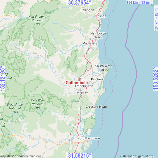
Collombatti GPS coordinates[2]
30° 58' 52.5" South, 152° 49' 30.252" East
| Map corner | latitude | longitude |
|---|---|---|
| Upper-left | -30.37654°, | 152.12195° |
| Center: | -30.98125°, | 152.82507° |
| Lower-right: | -31.58215°, | 153.5282° |
| Map W x H: | 134.1×134.1 km | = 83.3×83.3mi |
| max Lat: | -10.58257° ⇑29.2% North |
| Collombatti: | -30.98125° |
| min Lat: | ⇓70.8% South -43.31423° |
| min Long | Collombatti | max Long |
| 113.53327° | 152.82507° | 153.61246° |
| W 87.4%⇐ | ⇒12.6% E |
Elevation
Elevation of Collombatti is 9 m = 30 ft, and this is 113 m = 371 ft below average elevation for this country.
| Max E: |
1715 m = 5627 ft | 90.1% |
| Avg. | 122 m = 400 ft | |
| Collombatti | 9 m = 30 ft | |
Min E: |
-2 m = -7 ft | 9.9% |
See also: Australia elevation on elevation.city.
Geographical zone
Collombatti is located in South temperate zone (between Tropic of Capricorn and the Antarctic Circle). Distance of this Southern Tropic circle is 838.9 km =521.3 mi to North.| Distance of | km | miles | from Collombatti |
|---|---|---|---|
| Equator | 3444.8 | 2140.5 | to North |
| Tropic Capricorn | 838.9 | 521.3 | to North |
| Antarctic Circle | 3956.4 | 2458.4 | to South |
| South Pole | 6562.3 | 4077.6 | to South |


Nearby cities:
15 places around Collombatti: (largest is in red/bold)
• Aldavilla
12.4 km =7.7 mi,  205°
205°
• Crescent Head
27 km =16.8 mi,  148°
148°
• Dondingalong
18.3 km =11.4 mi,  202°
202°
• East Kempsey
11.5 km =7.1 mi,  166°
166°
• Frederickton
7.9 km =4.9 mi,  142°
142°
• Green Hill
8.9 km =5.5 mi,  194°
194°
• Kempsey
10.9 km =6.8 mi,  177°
177°
• Kempsey city centre
10.8 km =6.7 mi, 174°
• Kundabung
25.4 km =15.8 mi, 178°
• Smithtown
12 km =7.5 mi,  107°
107°
• South Kempsey
15.8 km =9.8 mi, 177°
• South West Rocks
23.2 km =14.4 mi,  62°
62°
• Stuarts Point
24 km =14.9 mi,  41°
41°
• West Kempsey
8.5 km =5.3 mi, 178°
• Yarravel
9.1 km =5.7 mi,  221°
221°
Sources, notices
• [Note1] Compared only with cities in Australia existing in our database
• [Src1] Map data: © OpenStreetMap contributors (CC-BY-SA)
• [Src2] Other city data from geonames.org with taken over terms of usage.
• [Src3] Geographical zone / Annual Mean Temperature by Robert A. Rohde @ Wikipedia
