Stuarts Point geodata
Stuarts Point (New South Wales) is a populated place; located in Australia in Australia/Sydney (GMT+11) time zone. With population of 806 people, there are 4132 cities with bigger population in this country. Compared to other cities in Australia, 71% of cities are located further ↓South; 90.9% of cities are located further ←West and 91.8% of cities have higher elevation than Stuarts Point. Note1


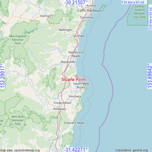
Stuarts Point GPS coordinates[2]
30° 49' 14.844" South, 152° 59' 35.844" East
| Map corner | latitude | longitude |
|---|---|---|
| Upper-left | -30.21507°, | 152.29017° |
| Center: | -30.82079°, | 152.99329° |
| Lower-right: | -31.42271°, | 153.69642° |
| Map W x H: | 134.3×134.3 km | = 83.5×83.5mi |
| max Lat: | -10.58257° ⇑29% North |
| Stuarts Point: | -30.82079° |
| min Lat: | ⇓71% South -43.31423° |
| min Long | Stuarts Point | max Long |
| 113.53327° | 152.99329° | 153.61246° |
| W 90.9%⇐ | ⇒9.1% E |
Elevation
Elevation of Stuarts Point is 8 m = 26 ft, and this is 114 m = 374 ft below average elevation for this country.
| Max E: |
1715 m = 5627 ft | 91.8% |
| Avg. | 122 m = 400 ft | |
| Stuarts Point | 8 m = 26 ft | |
Min E: |
-2 m = -7 ft | 8.2% |
See also: Australia elevation on elevation.city.
Geographical zone
Stuarts Point is located in South temperate zone (between Tropic of Capricorn and the Antarctic Circle). Distance of this Southern Tropic circle is 821 km =510.1 mi to North.| Distance of | km | miles | from Stuarts Point |
|---|---|---|---|
| Equator | 3427 | 2129.4 | to North |
| Tropic Capricorn | 821 | 510.1 | to North |
| Antarctic Circle | 3974.2 | 2469.5 | to South |
| South Pole | 6580.1 | 4088.7 | to South |


Nearby cities:
15 places around Stuarts Point: (largest is in red/bold)
• Bowraville
23.3 km =14.5 mi,  324°
324°
• Collombatti
24 km =14.9 mi,  221°
221°
• East Kempsey
32 km =19.9 mi,  204°
204°
• Frederickton
26.6 km =16.5 mi,  205°
205°
• Green Hill
32.2 km =20 mi, 214°
• Kempsey city centre
32.3 km =20.1 mi, 207°
• Macksville
14.4 km =8.9 mi,  330°
330°
• Nambucca
20.9 km =13 mi,  357°
357°
• Nambucca Heads
19.8 km =12.3 mi,  4°
4°
• North Macksville
14.9 km =9.3 mi,  341°
341°
• Scotts Head
8.1 km =5 mi, 1°
• Smithtown
22 km =13.7 mi,  192°
192°
• South West Rocks
8.5 km =5.3 mi,  147°
147°
• Valla Beach
25.4 km =15.8 mi, 3°
• West Kempsey
30.7 km =19.1 mi, 210°
Sources, notices
• [Note1] Compared only with cities in Australia existing in our database
• [Src1] Map data: © OpenStreetMap contributors (CC-BY-SA)
• [Src2] Other city data from geonames.org with taken over terms of usage.
• [Src3] Geographical zone / Annual Mean Temperature by Robert A. Rohde @ Wikipedia
