Tuzla geodata
Tuzla (Federation of B&H) is a seat of a second-order administrative division; located in Bosnia and Herzegovina in Europe/Sarajevo (GMT+2) time zone. With population of 142,486 people, there are 3 cities with bigger population in this country. Compared to other cities in Bosnia and Herzegovina, 54.7% of cities are located further ↓South; 81.9% of cities are located further ←West and 63% of cities have higher elevation than Tuzla. Note1


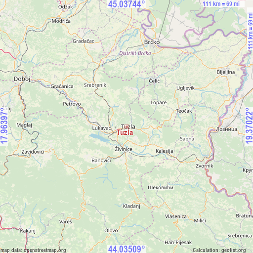
Tuzla GPS coordinates[2]
44° 32' 18.312" North, 18° 40' 1.524" East
| Map corner | latitude | longitude |
|---|---|---|
| Upper-left | 45.03744°, | 17.96397° |
| Center: | 44.53842°, | 18.66709° |
| Lower-right: | 44.03509°, | 19.37022° |
| Map W x H: | 111.5×111.4 km | = 69.3×69.2mi |
| max Lat: | 45.21956° ⇑45.3% North |
| Tuzla: | 44.53842° |
| min Lat: | ⇓54.7% South 42.71197° |
| min Long | Tuzla | max Long |
| 15.77806° | 18.66709° | 19.36719° |
| W 81.9%⇐ | ⇒18.1% E |
Elevation
Elevation of Tuzla is 225 m = 738 ft, and this is 134.5 m = 441 ft below average elevation for this country.
| Max E: |
1175 m = 3855 ft | 63% |
| Avg. | 359.5 m = 1179 ft | |
| Tuzla | 225 m = 738 ft | |
Min E: |
17 m = 56 ft | 37% |
See also: Tuzla elevation on elevation.city.
Geographical zone
Tuzla is located in North temperate zone (between Tropic of Cancer and the Arctic Circle). Distance of this Northern Tropic circle is 2346.3 km =1457.9 mi to South.| Distance of | km | miles | from Tuzla |
|---|---|---|---|
| North Pole | 5054.9 | 3141 | to North |
| Arctic Circle | 2449 | 1521.7 | to North |
| Tropic Cancer | 2346.3 | 1457.9 | to South |
| Equator | 4952.2 | 3077.2 | to South |


Nearby cities:
15 places around Tuzla: (largest is in red/bold)
• Barice
14.8 km =9.2 mi,  270°
270°
• Dubrave Donje
6.9 km =4.3 mi,  159°
159°
• Dubrave Gornje
8.7 km =5.4 mi,  147°
147°
• Gornja Tuzla
7.8 km =4.8 mi,  74°
74°
• Gornje Živinice
12.8 km =8 mi,  198°
198°
• Kiseljak
9.5 km =5.9 mi,  234°
234°
• Lukavac
11.2 km =7 mi, 272°
• Mramor
10.1 km =6.3 mi,  306°
306°
• Puračić
15 km =9.3 mi, 273°
• Solina
3.4 km =2.1 mi,  37°
37°
• Svojat
16.9 km =10.5 mi, 160°
• Tojšići
10.2 km =6.3 mi,  113°
113°
• Vukovije Donje
10.7 km =6.6 mi,  142°
142°
• Šerići
11.4 km =7.1 mi, 225°
• Živinice
10 km =6.2 mi,  187°
187°
Sources, notices
• [Note1] Compared only with cities in Bosnia and Herzegovina existing in our database
• [Src1] Map data: © OpenStreetMap contributors (CC-BY-SA)
• [Src2] Other city data from geonames.org with taken over terms of usage.
• [Src3] Geographical zone / Annual Mean Temperature by Robert A. Rohde @ Wikipedia
