Lukavac geodata
Lukavac (Federation of B&H) is a seat of a third-order administrative division; located in Bosnia and Herzegovina in Europe/Sarajevo (GMT+2) time zone. In our database, there are 234 cities with bigger population. Compared to other cities in Bosnia and Herzegovina, 55.5% of cities are located further ↓South; 75.8% of cities are located further ←West and 70.9% of cities have higher elevation than Lukavac. Note1


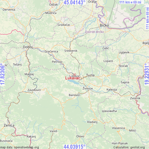
Lukavac GPS coordinates[2]
44° 32' 32.82" North, 18° 31' 34.248" East
| Map corner | latitude | longitude |
|---|---|---|
| Upper-left | 45.04143°, | 17.82306° |
| Center: | 44.54245°, | 18.52618° |
| Lower-right: | 44.03915°, | 19.22931° |
| Map W x H: | 111.4×111.4 km | = 69.2×69.2mi |
| max Lat: | 45.21956° ⇑44.5% North |
| Lukavac: | 44.54245° |
| min Lat: | ⇓55.5% South 42.71197° |
| min Long | Lukavac | max Long |
| 15.77806° | 18.52618° | 19.36719° |
| W 75.8%⇐ | ⇒24.2% E |
Elevation
Elevation of Lukavac is 194 m = 636 ft, and this is 165.5 m = 543 ft below average elevation for this country.
| Max E: |
1175 m = 3855 ft | 70.9% |
| Avg. | 359.5 m = 1179 ft | |
| Lukavac | 194 m = 636 ft | |
Min E: |
17 m = 56 ft | 29.1% |
See also: Bosnia and Herzegovina elevation on elevation.city.
Geographical zone
Lukavac is located in North temperate zone (between Tropic of Cancer and the Arctic Circle). Distance of this Northern Tropic circle is 2346.7 km =1458.2 mi to South.| Distance of | km | miles | from Lukavac |
|---|---|---|---|
| North Pole | 5054.4 | 3140.7 | to North |
| Arctic Circle | 2448.5 | 1521.4 | to North |
| Tropic Cancer | 2346.7 | 1458.2 | to South |
| Equator | 4952.7 | 3077.5 | to South |


Nearby cities:
15 places around Lukavac: (largest is in red/bold)
• Banovići
15.2 km =9.4 mi,  179°
179°
• Barice
3.6 km =2.2 mi,  266°
266°
• Dubrave Donje
15.2 km =9.4 mi,  116°
116°
• Dubrave Gornje
17.7 km =11 mi, 116°
• Gnojnica
10.7 km =6.6 mi,  324°
324°
• Gornje Živinice
14.5 km =9 mi,  150°
150°
• Kiseljak
6.9 km =4.3 mi, 149°
• Mramor
6.3 km =3.9 mi,  28°
28°
• Orahovica Donja
17.5 km =10.9 mi,  314°
314°
• Petrovo
16.7 km =10.4 mi,  304°
304°
• Puračić
3.8 km =2.4 mi,  275°
275°
• Solina
13.4 km =8.3 mi,  80°
80°
• Tuzla
11.2 km =7 mi,  92°
92°
• Šerići
8.9 km =5.5 mi,  160°
160°
• Živinice
14.3 km =8.9 mi,  136°
136°
Sources, notices
• [Note1] Compared only with cities in Bosnia and Herzegovina existing in our database
• [Src1] Map data: © OpenStreetMap contributors (CC-BY-SA)
• [Src2] Other city data from geonames.org with taken over terms of usage.
• [Src3] Geographical zone / Annual Mean Temperature by Robert A. Rohde @ Wikipedia
