Šerići geodata
Šerići (Federation of B&H) is a populated locality; located in Bosnia and Herzegovina in Europe/Sarajevo (GMT+2) time zone. With population of 3,663 people, there are 190 cities with bigger population in this country. Compared to other cities in Bosnia and Herzegovina, 50.2% of cities are located further ↑North; 77% of cities are located further ←West and 64.9% of cities have higher elevation than Šerići. Note1


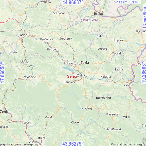
Šerići GPS coordinates[2]
44° 28' 0.264" North, 18° 33' 49.32" East
| Map corner | latitude | longitude |
|---|---|---|
| Upper-left | 44.96637°, | 17.86058° |
| Center: | 44.46674°, | 18.5637° |
| Lower-right: | 43.96279°, | 19.26683° |
| Map W x H: | 111.6×111.6 km | = 69.3×69.3mi |
| max Lat: | 45.21956° ⇑50.2% North |
| Šerići: | 44.46674° |
| min Lat: | ⇓49.8% South 42.71197° |
| min Long | Šerići | max Long |
| 15.77806° | 18.5637° | 19.36719° |
| W 77%⇐ | ⇒23% E |
Elevation
Elevation of Šerići is 221 m = 725 ft, and this is 138.5 m = 454 ft below average elevation for this country.
| Max E: |
1175 m = 3855 ft | 64.9% |
| Avg. | 359.5 m = 1179 ft | |
| Šerići | 221 m = 725 ft | |
Min E: |
17 m = 56 ft | 35.1% |
See also: Bosnia and Herzegovina elevation on elevation.city.
Geographical zone
Šerići is located in North temperate zone (between Tropic of Cancer and the Arctic Circle). Distance of this Northern Tropic circle is 2338.3 km =1453 mi to South.| Distance of | km | miles | from Šerići |
|---|---|---|---|
| North Pole | 5062.8 | 3145.9 | to North |
| Arctic Circle | 2456.9 | 1526.6 | to North |
| Tropic Cancer | 2338.3 | 1453 | to South |
| Equator | 4944.2 | 3072.2 | to South |


Nearby cities:
15 places around Šerići: (largest is in red/bold)
• Banovići
7.4 km =4.6 mi,  203°
203°
• Barice
10.5 km =6.5 mi,  321°
321°
• Dubrave Donje
10.7 km =6.6 mi,  81°
81°
• Dubrave Gornje
13 km =8.1 mi,  87°
87°
• Gornje Živinice
5.9 km =3.7 mi,  134°
134°
• Kiseljak
2.5 km =1.6 mi,  11°
11°
• Lukavac
8.9 km =5.5 mi,  340°
340°
• Mramor
14 km =8.7 mi,  0°
0°
• Puračić
11.1 km =6.9 mi, 322°
• Solina
14.8 km =9.2 mi,  44°
44°
• Svojat
16 km =9.9 mi,  119°
119°
• Tojšići
18 km =11.2 mi, 77°
• Tuzla
11.4 km =7.1 mi,  45°
45°
• Vukovije Donje
14.7 km =9.1 mi, 92°
• Živinice
7.1 km =4.4 mi,  105°
105°
Sources, notices
• [Note1] Compared only with cities in Bosnia and Herzegovina existing in our database
• [Src1] Map data: © OpenStreetMap contributors (CC-BY-SA)
• [Src2] Other city data from geonames.org with taken over terms of usage.
• [Src3] Geographical zone / Annual Mean Temperature by Robert A. Rohde @ Wikipedia
