Trn geodata
Trn (Srpska) is a populated place; located in Bosnia and Herzegovina in Europe/Sarajevo (GMT+2) time zone. With population of 7,553 people, there are 57 cities with bigger population in this country. Compared to other cities in Bosnia and Herzegovina, 77.4% of cities are located further ↓South; 74.3% of cities are located further →East and 84.5% of cities have higher elevation than Trn. Note1


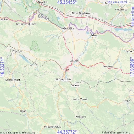
Trn GPS coordinates[2]
44° 51' 29.844" North, 17° 14' 8.988" East
| Map corner | latitude | longitude |
|---|---|---|
| Upper-left | 45.35455°, | 16.53271° |
| Center: | 44.85829°, | 17.23583° |
| Lower-right: | 44.35772°, | 17.93896° |
| Map W x H: | 110.8×110.8 km | = 68.8×68.8mi |
| max Lat: | 45.21956° ⇑22.6% North |
| Trn: | 44.85829° |
| min Lat: | ⇓77.4% South 42.71197° |
| min Long | Trn | max Long |
| 15.77806° | 17.23583° | 19.36719° |
| W 25.7%⇐ | ⇒74.3% E |
Elevation
Elevation of Trn is 135 m = 443 ft, and this is 224.5 m = 737 ft below average elevation for this country.
| Max E: |
1175 m = 3855 ft | 84.5% |
| Avg. | 359.5 m = 1179 ft | |
| Trn | 135 m = 443 ft | |
Min E: |
17 m = 56 ft | 15.5% |
See also: Bosnia and Herzegovina elevation on elevation.city.
Geographical zone
Trn is located in North temperate zone (between Tropic of Cancer and the Arctic Circle). Distance of this Northern Tropic circle is 2381.9 km =1480 mi to South.| Distance of | km | miles | from Trn |
|---|---|---|---|
| North Pole | 5019.3 | 3118.8 | to North |
| Arctic Circle | 2413.4 | 1499.6 | to North |
| Tropic Cancer | 2381.9 | 1480 | to South |
| Equator | 4987.8 | 3099.3 | to South |


Nearby cities:
15 places around Trn: (largest is in red/bold)
• Banja Luka
9.5 km =5.9 mi,  200°
200°
• Bronzani Majdan
24.4 km =15.2 mi,  252°
252°
• Hiseti
11.7 km =7.3 mi, 202°
• Kotor Varoš
28.8 km =17.9 mi,  158°
158°
• Krupa na Vrbasu
27.6 km =17.1 mi, 195°
• Laktaši
7.6 km =4.7 mi,  42°
42°
• Lamovita
27.4 km =17 mi,  284°
284°
• Maglajani
13.6 km =8.5 mi, 41°
• Marićka
30 km =18.6 mi,  272°
272°
• Mejdan - Obilićevo
11.2 km =7 mi, 198°
• Omarska
26.9 km =16.7 mi, 277°
• Piskavica
20.6 km =12.8 mi, 272°
• Starcevica
11.4 km =7.1 mi,  189°
189°
• Čelinac
14.7 km =9.1 mi,  153°
153°
• Čelinac
16.4 km =10.2 mi, 154°
Sources, notices
• [Note1] Compared only with cities in Bosnia and Herzegovina existing in our database
• [Src1] Map data: © OpenStreetMap contributors (CC-BY-SA)
• [Src2] Other city data from geonames.org with taken over terms of usage.
• [Src3] Geographical zone / Annual Mean Temperature by Robert A. Rohde @ Wikipedia
