Laktaši geodata
Laktaši (Srpska) is a seat of a second-order administrative division; located in Bosnia and Herzegovina in Europe/Sarajevo (GMT+2) time zone. With population of 6,464 people, there are 83 cities with bigger population in this country. Compared to other cities in Bosnia and Herzegovina, 83.4% of cities are located further ↓South; 72.1% of cities are located further →East and 85.3% of cities have higher elevation than Laktaši. Note1


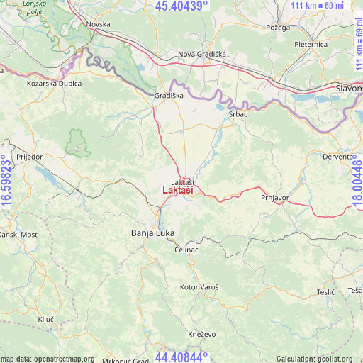
Laktaši GPS coordinates[2]
44° 54' 30.852" North, 17° 18' 4.86" East
| Map corner | latitude | longitude |
|---|---|---|
| Upper-left | 45.40439°, | 16.59823° |
| Center: | 44.90857°, | 17.30135° |
| Lower-right: | 44.40844°, | 18.00448° |
| Map W x H: | 110.7×110.7 km | = 68.8×68.8mi |
| max Lat: | 45.21956° ⇑16.6% North |
| Laktaši: | 44.90857° |
| min Lat: | ⇓83.4% South 42.71197° |
| min Long | Laktaši | max Long |
| 15.77806° | 17.30135° | 19.36719° |
| W 27.9%⇐ | ⇒72.1% E |
Elevation
Elevation of Laktaši is 124 m = 407 ft, and this is 235.5 m = 773 ft below average elevation for this country.
| Max E: |
1175 m = 3855 ft | 85.3% |
| Avg. | 359.5 m = 1179 ft | |
| Laktaši | 124 m = 407 ft | |
Min E: |
17 m = 56 ft | 14.7% |
See also: Bosnia and Herzegovina elevation on elevation.city.
Geographical zone
Laktaši is located in North temperate zone (between Tropic of Cancer and the Arctic Circle). Distance of this Northern Tropic circle is 2387.4 km =1483.5 mi to South.| Distance of | km | miles | from Laktaši |
|---|---|---|---|
| North Pole | 5013.7 | 3115.4 | to North |
| Arctic Circle | 2407.8 | 1496.1 | to North |
| Tropic Cancer | 2387.4 | 1483.5 | to South |
| Equator | 4993.4 | 3102.8 | to South |


Nearby cities:
15 places around Laktaši: (largest is in red/bold)
• Banja Luka
16.8 km =10.4 mi,  210°
210°
• Bronzani Majdan
31.2 km =19.4 mi,  245°
245°
• Gradiška
26.5 km =16.5 mi,  352°
352°
• Hiseti
19 km =11.8 mi, 210°
• Lamovita
31.7 km =19.7 mi,  272°
272°
• Maglajani
6 km =3.7 mi,  39°
39°
• Mejdan - Obilićevo
18.4 km =11.4 mi, 208°
• Omarska
31.8 km =19.8 mi, 266°
• Piskavica
26.1 km =16.2 mi,  259°
259°
• Prnjavor
28.8 km =17.9 mi,  98°
98°
• Srbac
27.3 km =17 mi, 39°
• Starcevica
18.3 km =11.4 mi,  202°
202°
• Trn
7.6 km =4.7 mi,  222°
222°
• Čelinac
18.8 km =11.7 mi,  175°
175°
• Čelinac
20.5 km =12.7 mi,  174°
174°
Sources, notices
• [Note1] Compared only with cities in Bosnia and Herzegovina existing in our database
• [Src1] Map data: © OpenStreetMap contributors (CC-BY-SA)
• [Src2] Other city data from geonames.org with taken over terms of usage.
• [Src3] Geographical zone / Annual Mean Temperature by Robert A. Rohde @ Wikipedia
