Stjepan-Polje geodata
Stjepan-Polje (Federation of B&H) is a populated locality; located in Bosnia and Herzegovina in Europe/Sarajevo (GMT+2) time zone. With population of 4,341 people, there are 145 cities with bigger population in this country. Compared to other cities in Bosnia and Herzegovina, 68.7% of cities are located further ↓South; 63.4% of cities are located further ←West and 59.6% of cities have higher elevation than Stjepan-Polje. Note1


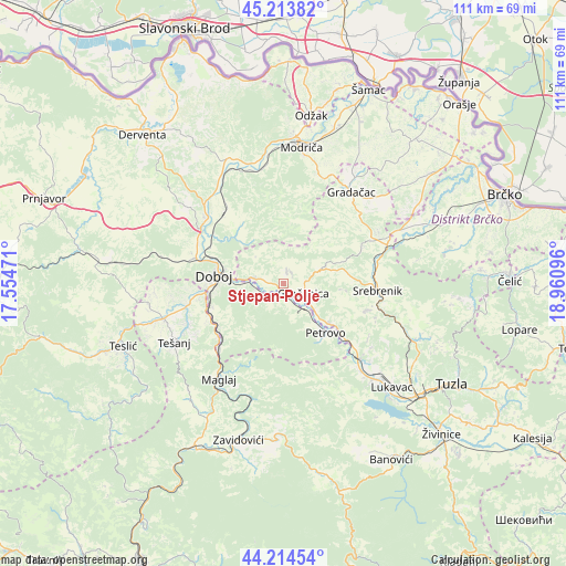
Stjepan-Polje GPS coordinates[2]
44° 42' 58.824" North, 18° 15' 28.188" East
| Map corner | latitude | longitude |
|---|---|---|
| Upper-left | 45.21382°, | 17.55471° |
| Center: | 44.71634°, | 18.25783° |
| Lower-right: | 44.21454°, | 18.96096° |
| Map W x H: | 111.1×111.1 km | = 69×69mi |
| max Lat: | 45.21956° ⇑31.3% North |
| Stjepan-Polje: | 44.71634° |
| min Lat: | ⇓68.7% South 42.71197° |
| min Long | Stjepan-Polje | max Long |
| 15.77806° | 18.25783° | 19.36719° |
| W 63.4%⇐ | ⇒36.6% E |
Elevation
Elevation of Stjepan-Polje is 239 m = 784 ft, and this is 120.5 m = 395 ft below average elevation for this country.
| Max E: |
1175 m = 3855 ft | 59.6% |
| Avg. | 359.5 m = 1179 ft | |
| Stjepan-Polje | 239 m = 784 ft | |
Min E: |
17 m = 56 ft | 40.4% |
See also: Bosnia and Herzegovina elevation on elevation.city.
Geographical zone
Stjepan-Polje is located in North temperate zone (between Tropic of Cancer and the Arctic Circle). Distance of this Northern Tropic circle is 2366.1 km =1470.2 mi to South.| Distance of | km | miles | from Stjepan-Polje |
|---|---|---|---|
| North Pole | 5035.1 | 3128.7 | to North |
| Arctic Circle | 2429.2 | 1509.4 | to North |
| Tropic Cancer | 2366.1 | 1470.2 | to South |
| Equator | 4972 | 3089.5 | to South |


Nearby cities:
15 places around Stjepan-Polje: (largest is in red/bold)
• Doboj
13.6 km =8.5 mi,  277°
277°
• Donja Međiđa
15 km =9.3 mi,  50°
50°
• Gnojnica
18.4 km =11.4 mi,  125°
125°
• Gradačac
22.5 km =14 mi,  36°
36°
• Gračanica
4.4 km =2.7 mi,  109°
109°
• Klokotnica
5.8 km =3.6 mi,  288°
288°
• Lukavica
8.8 km =5.5 mi,  307°
307°
• Maglaj
22.5 km =14 mi,  213°
213°
• Malešići
2.7 km =1.7 mi,  26°
26°
• Matuzići
16.8 km =10.4 mi,  259°
259°
• Orahovica Donja
11.3 km =7 mi, 128°
• Petrovo
12.4 km =7.7 mi,  142°
142°
• Sladna
13.3 km =8.3 mi,  83°
83°
• Srebrenik
18.2 km =11.3 mi,  92°
92°
• Tešanjka
20.1 km =12.5 mi, 255°
Sources, notices
• [Note1] Compared only with cities in Bosnia and Herzegovina existing in our database
• [Src1] Map data: © OpenStreetMap contributors (CC-BY-SA)
• [Src2] Other city data from geonames.org with taken over terms of usage.
• [Src3] Geographical zone / Annual Mean Temperature by Robert A. Rohde @ Wikipedia
