Lukavica geodata
Lukavica (Federation of B&H) is a populated locality; located in Bosnia and Herzegovina in Europe/Sarajevo (GMT+2) time zone. With population of 4,084 people, there are 153 cities with bigger population in this country. Compared to other cities in Bosnia and Herzegovina, 73.6% of cities are located further ↓South; 60% of cities are located further ←West and 67.9% of cities have higher elevation than Lukavica. Note1


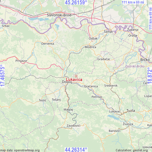
Lukavica GPS coordinates[2]
44° 45' 52.272" North, 18° 10' 7.932" East
| Map corner | latitude | longitude |
|---|---|---|
| Upper-left | 45.26159°, | 17.46575° |
| Center: | 44.76452°, | 18.16887° |
| Lower-right: | 44.26314°, | 18.872° |
| Map W x H: | 111×111 km | = 69×69mi |
| max Lat: | 45.21956° ⇑26.4% North |
| Lukavica: | 44.76452° |
| min Lat: | ⇓73.6% South 42.71197° |
| min Long | Lukavica | max Long |
| 15.77806° | 18.16887° | 19.36719° |
| W 60%⇐ | ⇒40% E |
Elevation
Elevation of Lukavica is 205 m = 673 ft, and this is 154.5 m = 507 ft below average elevation for this country.
| Max E: |
1175 m = 3855 ft | 67.9% |
| Avg. | 359.5 m = 1179 ft | |
| Lukavica | 205 m = 673 ft | |
Min E: |
17 m = 56 ft | 32.1% |
See also: Bosnia and Herzegovina elevation on elevation.city.
Geographical zone
Lukavica is located in North temperate zone (between Tropic of Cancer and the Arctic Circle). Distance of this Northern Tropic circle is 2371.4 km =1473.5 mi to South.| Distance of | km | miles | from Lukavica |
|---|---|---|---|
| North Pole | 5029.7 | 3125.3 | to North |
| Arctic Circle | 2423.8 | 1506.1 | to North |
| Tropic Cancer | 2371.4 | 1473.5 | to South |
| Equator | 4977.3 | 3092.7 | to South |


Nearby cities:
15 places around Lukavica: (largest is in red/bold)
• Doboj
7.4 km =4.6 mi,  240°
240°
• Donja Međiđa
19.1 km =11.9 mi,  77°
77°
• Gradačac
24 km =14.9 mi,  58°
58°
• Gračanica
13.1 km =8.1 mi,  121°
121°
• Jelah
20.6 km =12.8 mi,  233°
233°
• Klokotnica
3.9 km =2.4 mi,  155°
155°
• Malešići
8.8 km =5.5 mi,  109°
109°
• Matuzići
12.8 km =8 mi, 228°
• Omanjska
18.2 km =11.3 mi,  246°
246°
• Orahovica Donja
20.1 km =12.5 mi,  127°
127°
• Petrovo
21 km =13 mi,  136°
136°
• Sladna
20.7 km =12.9 mi,  101°
101°
• Stjepan-Polje
8.8 km =5.5 mi, 127°
• Tešanj
22.3 km =13.9 mi,  220°
220°
• Tešanjka
16.1 km =10 mi, 230°
Sources, notices
• [Note1] Compared only with cities in Bosnia and Herzegovina existing in our database
• [Src1] Map data: © OpenStreetMap contributors (CC-BY-SA)
• [Src2] Other city data from geonames.org with taken over terms of usage.
• [Src3] Geographical zone / Annual Mean Temperature by Robert A. Rohde @ Wikipedia
