Sapna geodata
Sapna (Federation of B&H) is a seat of a third-order administrative division; located in Bosnia and Herzegovina in Europe/Sarajevo (GMT+2) time zone. In our database, there are 234 cities with bigger population. Compared to other cities in Bosnia and Herzegovina, 53.2% of cities are located further ↓South; 92.5% of cities are located further ←West and 50.6% of cities have lower elevation than Sapna. Note1


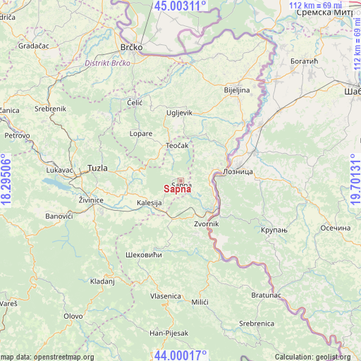
Sapna GPS coordinates[2]
44° 30' 13.68" North, 18° 59' 53.448" East
| Map corner | latitude | longitude |
|---|---|---|
| Upper-left | 45.00311°, | 18.29506° |
| Center: | 44.5038°, | 18.99818° |
| Lower-right: | 44.00017°, | 19.70131° |
| Map W x H: | 111.5×111.5 km | = 69.3×69.3mi |
| max Lat: | 45.21956° ⇑46.8% North |
| Sapna: | 44.5038° |
| min Lat: | ⇓53.2% South 42.71197° |
| min Long | Sapna | max Long |
| 15.77806° | 18.99818° | 19.36719° |
| W 92.5%⇐ | ⇒7.5% E |
Elevation
Elevation of Sapna is 288 m = 945 ft, and this is 71.5 m = 235 ft below average elevation for this country.
| Max E: |
1175 m = 3855 ft | 49.4% |
| Avg. | 359.5 m = 1179 ft | |
| Sapna | 288 m = 945 ft | |
Min E: |
17 m = 56 ft | 50.6% |
See also: Bosnia and Herzegovina elevation on elevation.city.
Geographical zone
Sapna is located in North temperate zone (between Tropic of Cancer and the Arctic Circle). Distance of this Northern Tropic circle is 2342.4 km =1455.5 mi to South.| Distance of | km | miles | from Sapna |
|---|---|---|---|
| North Pole | 5058.7 | 3143.3 | to North |
| Arctic Circle | 2452.8 | 1524.1 | to North |
| Tropic Cancer | 2342.4 | 1455.5 | to South |
| Equator | 4948.4 | 3074.8 | to South |


Nearby cities:
15 places around Sapna: (largest is in red/bold)
• Dubrave Donje
24 km =14.9 mi,  263°
263°
• Dubrave Gornje
21.8 km =13.5 mi, 260°
• Gornja Tuzla
19.7 km =12.2 mi,  287°
287°
• Kalesija
10.3 km =6.4 mi,  224°
224°
• Lopare
19.1 km =11.9 mi,  319°
319°
• Osmaci
13.1 km =8.1 mi,  209°
209°
• Petkovci
7.2 km =4.5 mi,  122°
122°
• Priboj
12.2 km =7.6 mi,  334°
334°
• Solina
25 km =15.5 mi, 285°
• Svojat
23.9 km =14.9 mi,  239°
239°
• Teočak
11.2 km =7 mi,  352°
352°
• Tojšići
16.9 km =10.5 mi,  269°
269°
• Ugljevik
17.9 km =11.1 mi,  5°
5°
• Vukovije Donje
20.3 km =12.6 mi, 256°
• Zvornik
15.5 km =9.6 mi,  147°
147°
Sources, notices
• [Note1] Compared only with cities in Bosnia and Herzegovina existing in our database
• [Src1] Map data: © OpenStreetMap contributors (CC-BY-SA)
• [Src2] Other city data from geonames.org with taken over terms of usage.
• [Src3] Geographical zone / Annual Mean Temperature by Robert A. Rohde @ Wikipedia
